click on image ↑ for full size
|
[Home] to paraglide.net [SD Log] [Amigo] [Activity] [Photo] [Comments] [Incidents] [Weather] [SBSA] [SCPA] |
| [Amigo] > [Bummy archive index] |
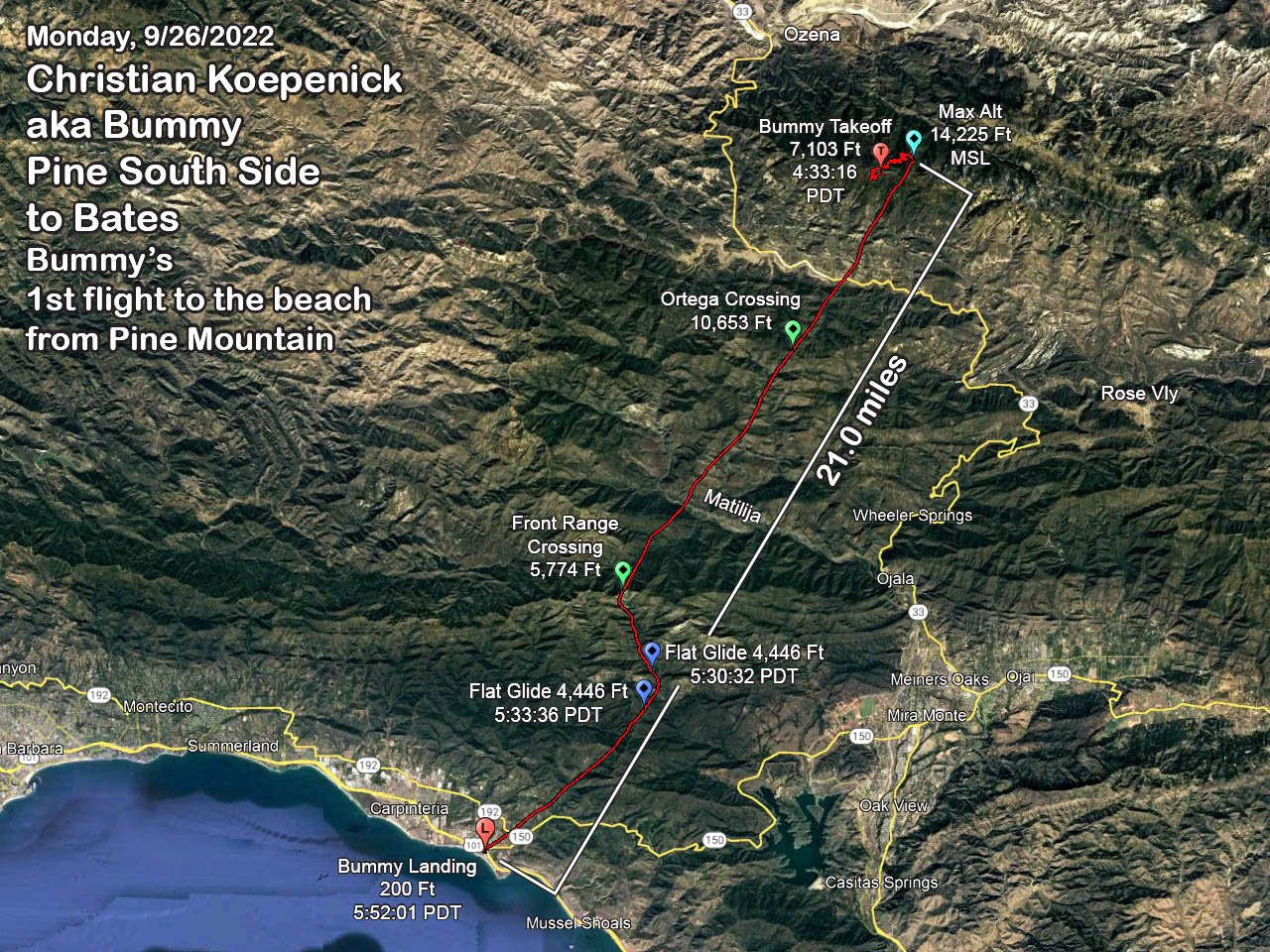
Christian Koepenick aka Bummy
Monday, 9/26/2022
Pine SS to Bates (Bummy's 1st flight to the Beach from Pine Mt)
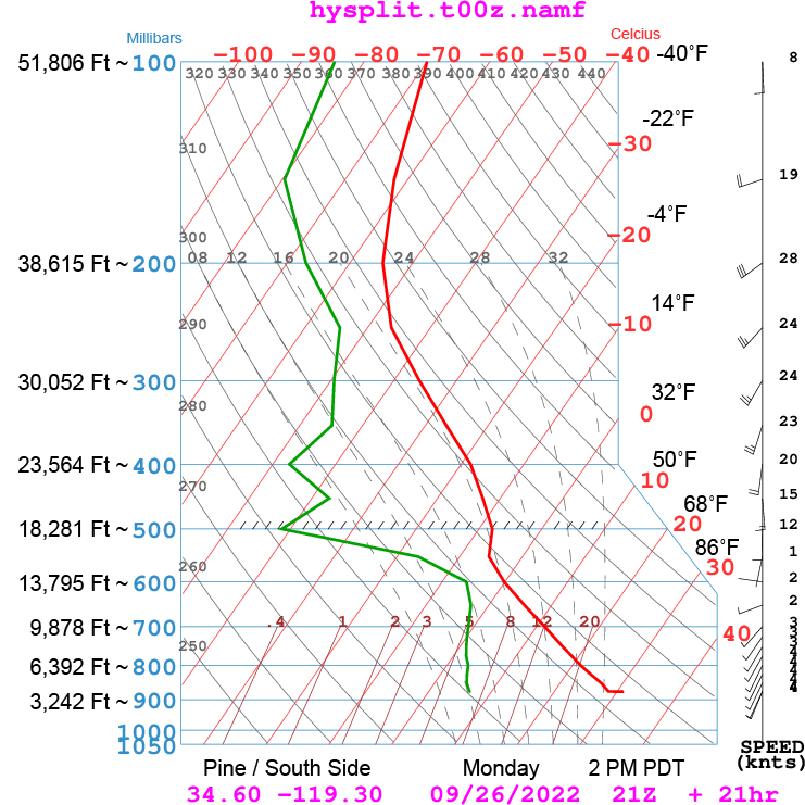
Reference: [IGC Text Data File] and [Google Earth KMZ File] and [JPG Overview] and [NAM Skew-t]
21.0 Miles Straight Line Over-Flown Distance (SLOFD)
Max Altitude 14,225 Ft MSL
1 hours 18 minutes 45 seconds / Launch at 4:33:16 / Land at 5:52:01 PDT
click on image ↓ for full size
click on image ↑ for full size
Bummy' s Narrative extracted from Telegram and email exchange with Tom Truax (aka SD)
SD / Friday, 10/21 at 00:07 PDT
Looks like you had a light headwind on your 1-hour glide? I suspect you
wish you didn’t waver after crossing the front range? Did you opt to
change your mind and reach for the beach because you flew though a buoyant zone
for 3 minutes (tick open the altitudes folder). The Carp weather station
on Foothill was reporting 3 to 5 from the SW at 5:50 PM. Did you land with
a quartering tailwind after squeaking across the freeway? Did you land in
the bushes, or is your GPS off by 15 feet?
Congratulations on your many recent stellar flights…
Bummy / Friday, 10/21 at 22:52 PDT
On my glide from Pine I certainly questioned my glide ratio. Especially
since it was my first flight on my new Rush 6 (previously on a Buzz Z6). Dave Patterson was ahead of
me with 15,500 top of lift. Almost 1k above what I’d left with. I
launched 15 minutes after him and the climbs were slow and smooth in glass off
conditions. Lift was friendly and soft, tapering off so I opted to leave
with less assuming the day was winding down. As it was my first attempt
pushing over the front range from Pine I had no reference and was constantly
doubting my distance and potential. I crossed the front range lowish just
east of East Divide Peak (58ish) and opted to angle toward Ojai / Lake Casitas.
I encountered what I thought was a convergence over the pass spine (Chismahoo)
so I changed course. For a bit I thought I might actually come in over the
top of Rincon Mountain. The rest of my glide I was unsure but hopeful.
I eyed Cate school, the Van Wingerden 192 field, and the raspberry fields near
the Carp/Rincon industrial park as possible bail outs. I was determined to
make the coast. Dave Patterson and Chris Gulden made Viola Field, but with
a slight headwind from the west I needed to fall off hoping to make Bates as a
best case scenario. I came in low. So low that I thought I might
have to land on the Bates freeway over pass. After clearing the 101
freeway I turned left towards Rincon to try for a top landing at Bates into the
wind but I swiftly lost altitude and as you speculated landed downwind in the
bushes . Haha! Just shy of Bates between the parking lot and launch. I
considered it a win and licked my wounds headed home with a good story and some
lessons learned.
ID: SE500
NAME: SCE Carpinteria (Carp Foothill Rd near Linden Ave)
LATITUDE: 34.40700
LONGITUDE: -119.51029
ELEVATION: 44 ft
MNET: SC-EDISON
Observations for Monday 09/26/2022 16:50 to 18:50 PDT
|
Time (PDT) |
Temp ° F |
Dew Point ° F |
Relative Humidity % |
Wind Speed mph |
Wind Gust mph |
Wind Direction |
|---|---|---|---|---|---|---|
| 18:50 | 68.7 | 64.1 | 85 | 1.1 | 2.2 | SSW |
| 18:40 | 68.9 | 64.1 | 85 | 1.7 | 3.1 | SW |
| 18:30 | 69.3 | 64.1 | 83 | 1.9 | 3.6 | SW |
| 18:20 | 70.0 | 64.1 | 82 | 2.3 | 4.3 | WSW |
| 18:10 | 70.4 | 64.0 | 80 | 2.6 | 4.7 | SW |
| 18:00 | 71.3 | 63.9 | 78 | 3.0 | 4.7 | SW |
| 17:50 | 72.2 | 63.6 | 75 | 3.0 | 5.3 | SW |
| 17:40 | 72.8 | 63.2 | 72 | 2.9 | 5.6 | WSW |
| 17:30 | 72.8 | 63.4 | 72 | 3.0 | 5.8 | SW |
| 17:20 | 73.3 | 62.7 | 70 | 3.3 | 5.6 | SW |
| 17:10 | 73.7 | 62.3 | 68 | 3.8 | 7.3 | WSW |
| 17:00 | 73.3 | 62.3 | 68 | 4.2 | 7.6 | SW |
| 16:50 | 74.6 | 62.1 | 65 | 3.4 | 8.3 | SW |
[Top of Page] [Home]