click image for full size / 1600x800
|
[Home] to paraglide.net [SD Log] [Amigo] [Activity] [Photo] [Comments] [Incidents] [Weather] [SBSA] [SCPA] |
| [Amigo] > [Carter Crowe archive index] |
Carter Crowe
Tuesday, 6/9/2020
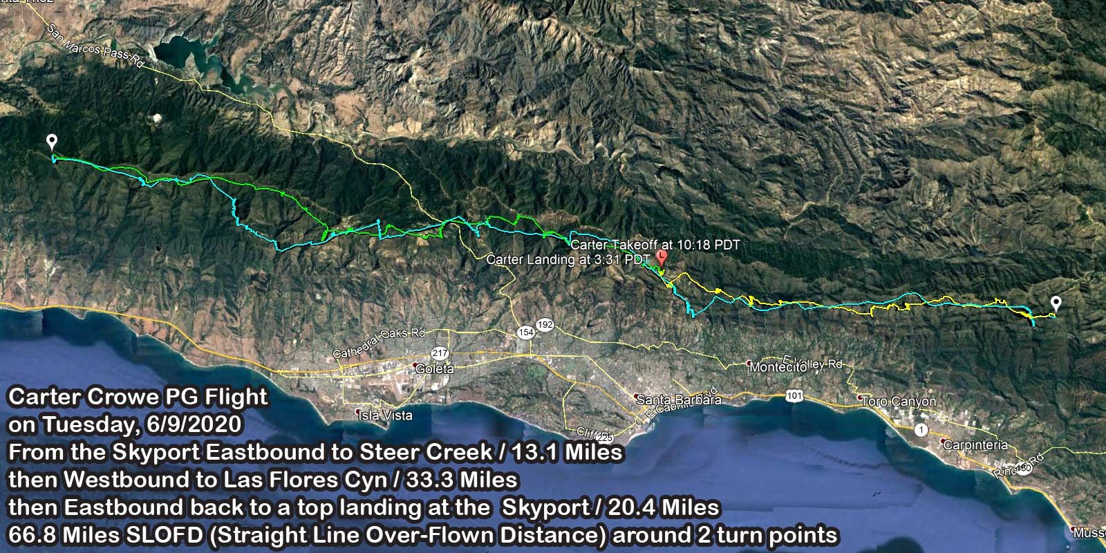
Skyport Eastbound to Steer Creek then
Westbound to Las Flores Cyn then
return Eastbound to top land at the Skyport
Reference: [IGC Text Data File] and [Google Earth KMZ File] or [Ayvri Web Animation] and [JPG Overview]
Skyport to Steer Creek (a little short of Divide Peak) / 13.1 Miles
Steer Creek to Las Flores Canyon / 33.3 Miles
Flores Canyon back to the Skyport / 20.4 Miles
66.8 Miles SLOFD (Straight Line Over-Flown Distance) around 2 turn points.
Launch at 10:18 PDT, Land at 3:31 PDT / 5 hours 13 minutes total airtime
click image for full size / 1600x800
Article Copied from the SBSA Telegram Chat
Posted by Carter at
8:16 PM on Tuesday 6/9/2020
with minor edits by Tom Truax to clarify place names
Skyport to Skyport - Ozone LM6 - Supair Skypper 2
Forecast for the day was promising, good lapse rate up to 5k+, East wind with the potential for South/Southwest in the afternoon on the front range.
My goal when I set out to fly was to get to Ojai and back.
Upon arrival at Skyport, cycles were very light. They were building, slowly, almost imperceptibly, but I resolved to wait, knowing that the quality lapse rate was not to be wasted on my impatience - I lasted 20 minutes. Despite my early launch, I was able to hang in zeroes at Skyport and Thermal Factory before pressing into the East wind.
The trip to East Divide was largely un-remarkable, climbs up to 4-4.5k and a 5-10 mph headwind. Climbs were gaining speed over the course of my trip East, starting around 1-2m/s and topping out at 5.5+m/s at Noon Peak. I noticed the East wind becoming more solid with a very strong South draw below ridge-height at the Power Lines but decided to push forward, the turbulence was not un-manageable and I was still getting 6-8:1 glides. After a strong climb at Noon, I pressed on full bar towards West Divide. I gave the glide an honest shot, but when the glide ratio hit 2-3:1, ground speed less than 5 mph and the air became increasingly turbulent, I decided to throw in the towel on the Ojai plan and look for something else to do.
I climbed back out to 5k at Noon Peak. I had one hell of a tail wind, a fair bit of altitude and had given up on my declared goal for the day, so I popped open a can of Lemon La Croix and set off on glide, doing 30-35+mph on trim. After passing Snowball, it became clear I could make something of the glide, my ennui had passed, with a new sense of resolve I began bobbing and weaving, sniffing for the slightest hint of lift.
I arrived at Montecito Peak, still on glide from Noon and flew into a boomer of a thermal. One part of me thought, "hey, it makes sense to climb here", so I promptly stepped on the bar (because that makes everything better when you start needing to really find lift) and dove into Shadow, and eventually Parker's, quite low.
Satisfied with my glide, I climbed out of Parker's, slowly at first. The lapse wasn't quite as good down low, but the light South breeze was a pleasant change from the howling east at West Divide. I got back up to 5k at RR and figured I might as well ride the tail wind. With a West wind supposedly coming in at some point, I'd be foolish not to ride the tail wind out to VOR or Painted Cave and get an easy ride back. It was nice to see Andrew Byron and Brian Kaiserauer launch EJ and glide out to East Beach. It had been a bit of a lonely flight up until then.
After a couple more climbs and glides I arrived at Painted Cave. Dilan Benedetti came on the Radio! I couldn't see him, but I knew he was there. I searched for his Zeno but didn't find him - ok, time to think about what I'm doing again... Still East wind, might as well keep going, eh? I hopped over the 154 and instantly turned my feelers on. I had to find the West wind. As I continued west I began noticing a small band of South wind between 3-4k. The East was still quite strong up high, but the South was a nice change of pace. I arrived at the Broadcast antennas after ridge soaring up the South faces, eventually arriving at Santa Ynez Peak. A small climb up to 5k and I still had East wind, but It was almost 2pm and I wanted to get home at a reasonable hour.
Alas, I turned around at the last prominent "peak" on the main Santa Ynez group. Getting back was going to be a challenge, but the 3-4k south band had been slowly shifting west on my journey past Santa Ynez Peak. If I could just stay in that air I could make it back.
I ridge soared most of the way back between 3-3.5k, the tailwind was light, but better than climbing up to 5k+ and battling the headwind. I opted for a deep line where I could hug the south-facing slopes. It worked out, and the band of West wind grew to about 2.5-4.5k by the time I reached Hwy 154, giving me a little more room to operate. I found a light climb just West of the 154 and frisbeed across. A small bump at Painted Cave and a climb to my highest altitude of 5300 at No Name (with Uncle Neal passing below!) gave me enough altitude to get back to my car at Skyport and see Derek Musashe up high at RR. I landed 5 feet from my car.
My vario says I landed something like 29 meters from where I launched - after completing a flat triangle of 108km (67 miles!) without going through the pass into Ojai. Tom kindly offered a ride from Ojai back to SB if I wanted to fly some more, but I was pooped. Good day in the SB skies.
[Top of Page] [Home]