|
[Home] to paraglide.net [SD Log] [Amigo] [Activity] [Photo] [Comments] [Incidents] [Weather] [SBSA] [SCPA] |
| [Amigo] > [Dave Turner paraglide.net flight index] |
| Dave's Website http://sierraparagliding.com / Dave's Viemo Video Index: http://vimeo.com/user5961980/videos |
| Dave's Leonardo Index: http://www.paraglidingforum.com/leonardo/tracks/world/alltimes/brand:all,cat:,class:all,xctype:all,club:all,pilot:0_30215,takeoff:all : |
Dave Turner
6/27/2013
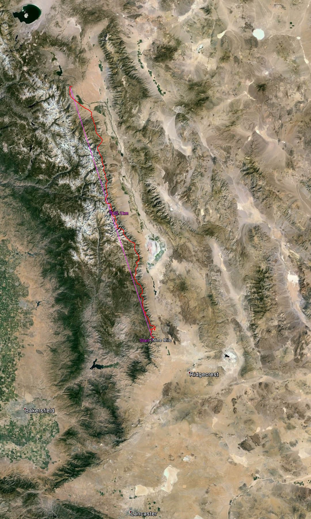
121 Mile Paraglider Flight from Nine Mile Launch
from the southern end of the Sierra Range to Swall Meadows
about 17 miles NW of Downtown Bishop
Sundowner Comments 1/23/2014
Nine Mile Launch is about 6-1/2 miles up a paved road named Nine Mile Canyon
Road that heads west from Hwy 395.
The intersection of Nine Mile Canyon Road and Hwy 395 is about 2 miles north of
the north end of Pearsonville
or about 10 miles north of the junction of Hwy 14 and Hwy 395. Nine Mile
Canyon Road turns into Kennedy Meadow Road (J41)
I (Sundowner) haven't flown the site, but from Dave's track log it appears
Dave's launch is below the tree line with about 13 or 1500 vertical to the
canyon bottom. I think you have to hike above the road to get to launch,
the higher the better?, but from Dave's track log, it appears he hiked about 350
vertical.
An advantage of this launch is that if you can get up at launch, you can fly
over a hundred miles along the Sierra without crossing the valley.
A disadvantage is that launch is low and back in a canyon, so launch likely
doesn't work as good as Walts Point or Pine Mountain.
No Flight Article, but Data Posted on Leonardo at:
http://www.paraglidingforum.com/leonardo/flight/77211
| Pilot name | Dave Turner | |
| Glider type | IcePeak 6 | |
| Take-off time | 10:19:10 | |
| Landing time | 17:20:14 | |
| Duration | 7h 01m 04s | |
| Take-off altitude | 1615m | 5417 Ft |
| Maximum altitude | 4564m | 14974 Ft |
| Minimum altitude | 1573m | 5161 Ft |
| Landing altitude | 2018m | 6621 Ft |
| Total altitude gain | 19014m | 62, 382 Ft |
| Maximum altitude gain | 2991m | 9813 Ft |
| Maximum climb | 4.5m/s | 886 Ft/Sec |
| Maximum sink | -4.8m/s | -945 Ft/Sec |
| Maximum speed | 73.5km/h | 45.7 MPH |
or click on image below ↓ to view full
size, or view Google Earth [KMZ File]
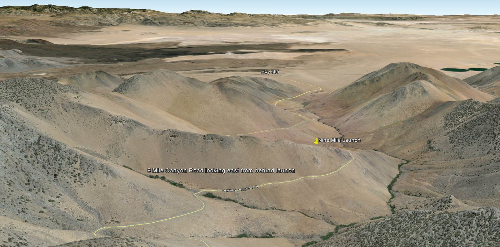
Click Image ↓ for Full Size Nine Mile
Launch Looking East from behind Launch
[Top of Page] [Home]