[Home] to paraglide.net [SD Log] [Amigo] [Activity] [Photo] [Comments] [Incidents] [Weather] [SBSA] [SCPA]
Thursday, 5/15/2014 [Weather] and [Flight Articles] by [Spin Dotor] [Cortfly] [Dizzy] & [Sundowner] [Photos]
Weather Archive
and Summary for Thursday, 5/20/2014
see also [Flight Articles]
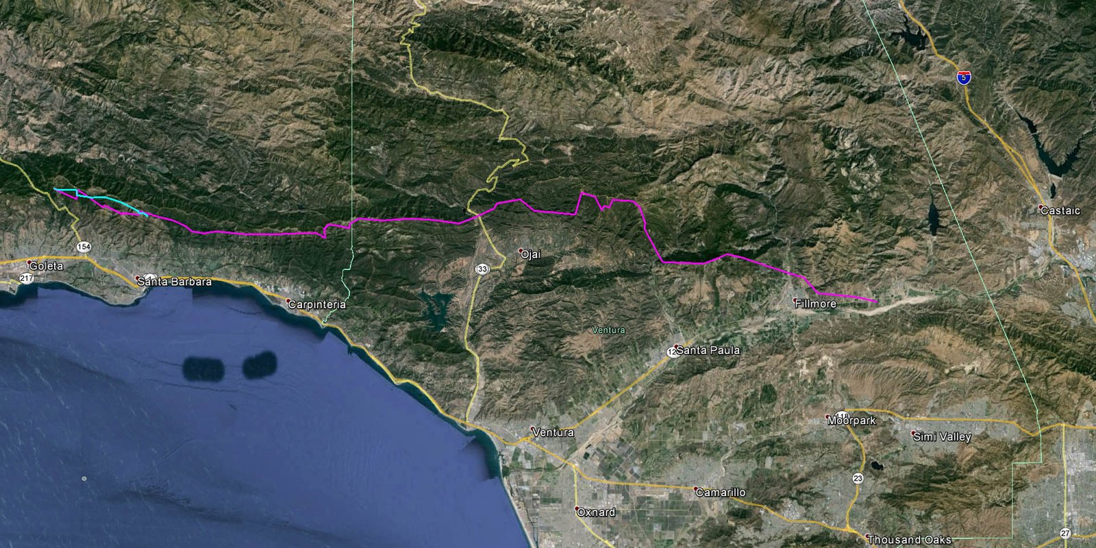
[Track Image] or Google Earth [KML
File] & [Photos]
Typically, I review the perceptions of various professionals and regurgitate my interpretation of how their predictions affect our options. If the models are wrong (with all the variables they are always off about something), then my preflight perceptions can miss the mark by a barnyard. Timing can play a huge part. Fortunately, during the NWS forecast discussion regarding our recent heat wave, the professionals didn't need to update much because the actual weather was tracking the model predictions pretty well. When I skip work to fly on a weekday, I want to choose the better of several days. The validity of the recent model runs and the slow moving system made the choice of Thursday less stressful.
Wednesday was a tad cooler on the surface, but significantly cooler aloft, so it had the most robust lapse rate and higher altitudes, but it also blew offshore Santa Anna down the Santa Clara River all day so Wednesday's XC potential didn't warrant the loss of production. Thursday was hotter on the surface, but also warmer aloft, so it's lapse rate as a little weaker than Wednesday, but it was the start of a switch from offshore gradients to onshore, and it was forecasted to blow up river in the afternoon. Friday was progressing toward increasing onshore gradients and associated surface cooling, but it was trending warmer at altitude, so the lapse rate looked like it may be problematic near the coast (Santa Barbara front range behind Summerland).
Having the weather reports from Wednesday was a big help on Thursday. While Ron and I were lounging in the shade at La Cumbre Peak, we reviewed Wednesday's timing and Thursday's switch matched up within a few minutes of Wednesday.
The morning inversion was really low, only a few hundred feet. The Montecito station (1500 Feet) was reporting 80°F at dawn and 90° before 10 am. The barometer was a little high, but not way high. Many locations reported record high surface temperatures Thursday, but the day was a bit unusual in that many coastal locations were reporting higher temperatures than inland locations. Not sure of the mechanics that enabled that phenomena. It wasn't a windy day, but there was more wind in the mountains than in the channel as noted by the buoy data and the flat ocean surface in the photo set.
It was blowing down from the NE up until about 10 am, it then waffled for a half hour and came upslope steady by 10:30. It was likely soarable by 11. The early air was nice, but it got progressively bumpier after noon. By 1 o'clock it had enough punch that I wanted to keep some terrain clearance. My canopy was wiggling around quite a bit, requiring active hands on control, but there weren't any weird spanky edges. My active hands on control is pretty much auto reflex without much brain drain, but it is still unsettling. It was typical high pressure turb without much wind, but amplified due to the extreme temperatures. It started to mellow around 3 PM.
Pilots stayed up late on Wednesday (5 pm), and I suspect it worked late on Thursday, but I was on the ground before 4 PM. The lapse rate was fading a bit late in the day Thursday, but it was still plenty hot on the surface and I got 7300 a little after 3 PM. I was expecting a thousand feet more altitude over the Topa Bluffs. The altitudes were likely a bit better on Wednesday.
Preflight Perceptions
copied from:
http://scpa.info/bb/forum/viewtopic.php?f=1&t=3046
Mid May Heat Wave
Wednesday night update for Thursday
Not sure if Eagle will be running a bus. I'm intending to catch a ride to SB in
the morning with Pam on her way to work, then will likely thumb up to launch.
Ron Faoro may be on board early, and Aaron will be along later after his 10:30
meeting. HG pilots have been reporting good altitude locally, getting into the
mid 5s and flying late into the afternoon (5 PM).
The forecast is on track for the east to clock around and blow from the west
Thursday afternoon. It blew offshore Santa Anna (from the east) almost all day
down the Santa Clara today (Wednesday). It did finally come up the river a ways
at the end of the day with the Oxnard airport reporting stiff onshore around 3
PM, but Santa Paula was offshore until after 5:30. Fillmore and Piru blew down
river past sunset. Expect the sea breeze to plow up the river much earlier
tomorrow (Thursday). Winds aloft start out from the east but clock around and
blow from the west at all locations in the afternoon.
Wednesday was west down low on the South Coast, but it was east up higher (above
6K). Wednesday's lapse rate was ballistic. Thursday's lapse rate still looks ok
in SB and strong in Ojai. Max temperatures topping 100 degrees F are actually
forecasted to be higher in Ojai than the high desert by 5 or 6 degrees F.
Plan to launch as early as possible (10:30 to 11:15ish?) and try and get through
Casitas Pass before the west sweeps through. My be able to connect OTB toward
Old Man Mountain from Divide, but there is some north and the lapse rate isn't
as good above 9K until later in the day (the top of the lift over Pine does
approach 11K later in the afternoon and 13K over Lockwood). A middle route may
work better. Perhaps committing back behind the Topa Bluffs past Hines Peak
toward Devils Heart, but that may be more of a Dave Turner move because if it
doesn't work it is a 2 or 3 day hike to get out, which is beyond my physical
capabilities. Top of the lift over the Topa Bluffs looks like 8 or 9K late in
the day.
__________________________________________
Tuesday night perception of the next few days...
Wednesday looks like the best lapse rate, but the east wind Wednesday seems to
be persistent. It will likely work ok in SB, switching from the west later in
the afternoon, but it may be problematic going east against a headwind that
increases toward the east end of the course.
Thursday has a weaker lapse rate, but it is also forecast to be a switch day
with the sea breeze pulling up river later in the afternoon. I suspect the best
potential might be to launch from Chiefs early for an initial west bound leg,
but I don't think the road will be open. It's too hot to hike the Nuthouse and
the Nut won't work as early as Chiefs. If you are going to launch later you
might as well start from SB and skip the hike. I suspect it should be soarable
by 11, so a short west bound leg looks like a possibility before the west pushes
through. Going OTB around Divide may be possible, but not sure if the altitude
will be good enough to get back to Pine. You may be able to launch from Pine on
Thursday, but I suspect it will work on the front range and we have all summer
to fly Pine. I recommend taking advantage of a late season front range
opportunity
Friday still looks ok in Ojai, but the current forecast is calling for the sea
breeze to cool down the coastal zones, so SB looks inverted by Friday.
I may try to fly Thursday from SB if I can align some of my issues. I'd prefer
to hold out until Saturday, but by then you will need to go inland to get away
from the cool ocean air. There should be some sea breeze in SB Thursday
afternoon, so it may work better earlier near the coast, but it should still be
hot inland later in the afternoon.
A note of caution. The lapse rate looks strong, so don't expect mild conditions
midday. I do expect it to mellow late in the afternoon on Thursday with Ojai
forecasting temperatures over 100 degrees. When we get 100 degree days in the
summer, the 6K temperature is typically running around 75 degrees, but
Wednesday's forecasted 6K temp is only about 65, which equates to a 35 degree
spread from the surface to 6K in Ojai (ballistic) and a 25 degree spread in SB
(strong). Sometimes the potential is better with a weaker lapse rate because
what goes up must come down, so days with strong lift typically also have strong
sink which shortens our reach on glide. The days are long and it should work
late, so try to stay in the game to enjoy the late afternoon inland air.
I'm open to flying tandem if you want to explore XC and don't mind the front
seat
Pre Day weather preceptions for Friday (the day
after)
copied from:
http://scpa.info/bb/forum/viewtopic.php?f=1&t=3046#p9034
cortfly wrote:
"It was an amazingly good day... (Thursday)
... the forecast conditions for tomorrow look very similar, with maybe a little
earlier and stronger onshore push. Professor Truax, if you're back yet, could
you give us the pleasure of your prognostications ?"
SD Response:
Friday Morning Update:
The lapse rate looks weaker than Thursday, warmer at 6K and cooler at the
surface. Wednesday had the strongest lapse rate, weaker on Thursday, and weaker
still on Friday, but Friday may still be good enough early. On Thursday, the sea
breeze did pull up the Santa Clara River all the way to the desert, but there
wasn’t much of a breeze in the Channel or at the beach. Kind of an odd day
Thursday with the coastal zones heating up as much or more than the inland
locations. More wind in the Channel this morning and stronger on-shore gradients
compared to Thursday. The NWS Discussion is calling for early heating followed
by afternoon cooling near the beach, so I suspect it will likely work better
early rather than late in the afternoon. The winds aloft forecast is also
calling for more flow from the WNW this afternoon compared to Thursday.
_______________________________________
Thursday Night Perception Regarding Friday:
The Lapse rate looks a little weaker Friday, 3 to 5 degrees cooler down low and
perhaps a tad warmer aloft, but it was stronger than desired Thursday, so I
suspect Friday will be good enough. A little more west at altitude on Friday,
and then significantly more onshore flow from the west this weekend. Ojai should
continue to boom Friday (hit 7300 at several locations Thursday), and hopefully
SB will be good enough to get past the low points behind Summerland. It was
pretty easy going Thursday with altitude to spare, so there is some wiggle room
for weaker lift. Thursday was blowing OTB at 10, cycling in at 10:45, and
soarable at 11. I got up easily from the Skyport launch at 11:15. It was also
working at EJ’s, but it was good down low, so there was no need to extend the
vehicle retrieve. The air was nice early, but by one o’clock it had some punch,
and by 2 I was motivated to keep my hands on the steering handles. It did mellow
out late in the day over Santa Paula Ridge. A little west wind in the afternoon
on Thursday, but not enough to tear the thermals. Expect a bit more west Friday
afternoon. The back ridges worked good early on Thursday, but later in the day
there was some south wind over the Ojai ridges, I suspect due to a venturi as
the back range mountains were drawing.
[Top of Page] [Home]