[Home] to paraglide.net [SD Log] [Amigo] [Activity] [Photo] [Comments] [Incidents] [Weather] [SBSA] [SCPA]
Saturday, 6/13/2015 [Weather]
and [Flight Articles]
by [Sundowner] & [Go
Sailplane Pilots]
Google Earth [sd KMZ]
/ [sd IGC] Data File / [SD Photos]
and [JD
Photos] [Reflections]
Saturday, 6/13/2015
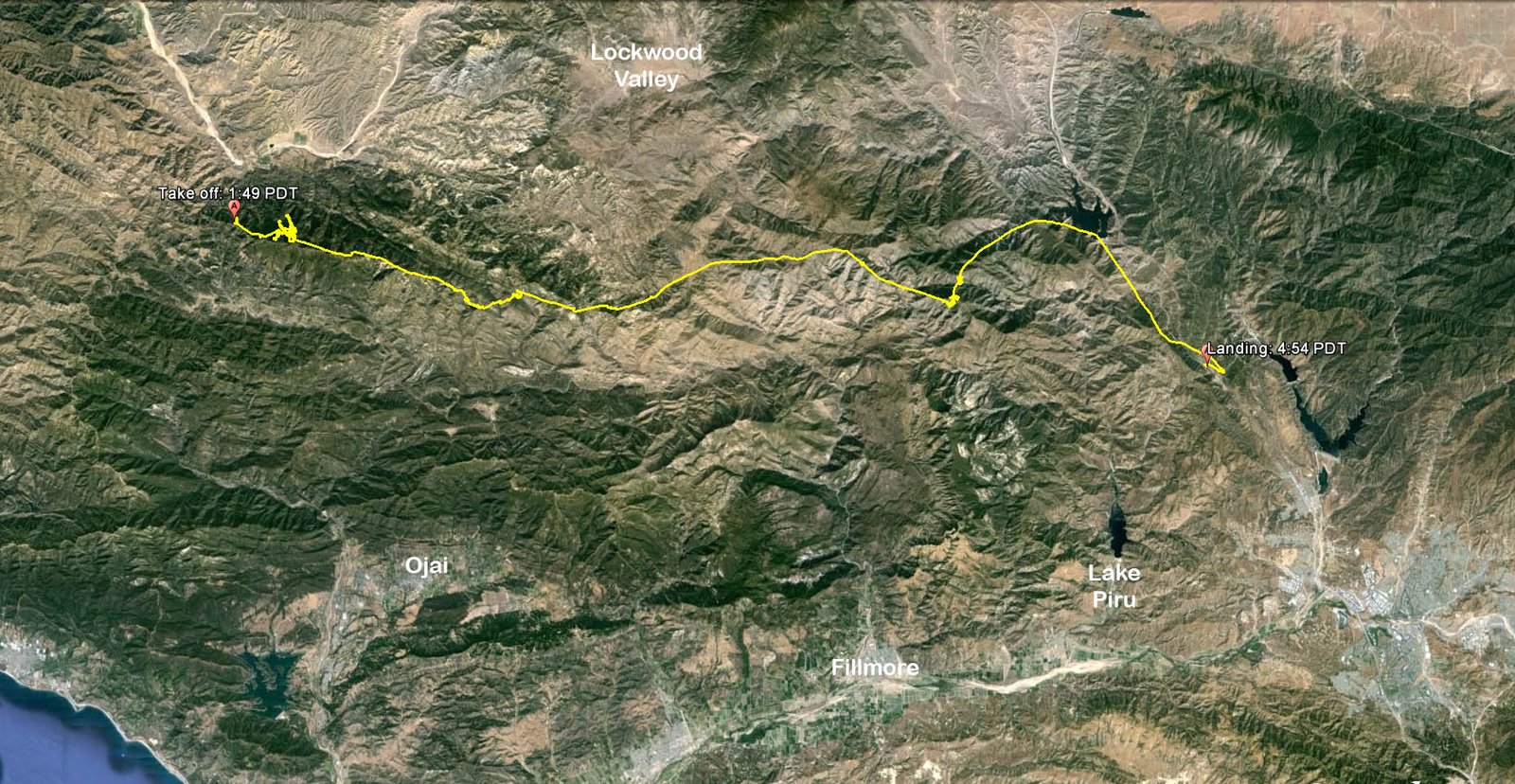
Pine North Side to I-5 and then south bound
Longest let just over 39 miles
3 hours airtime ~ Launch at 1:49 and land at 4:54
Niviuk Icepeak 6
Sundowner's Flight Report, see also [Weather Archive]
My glider had been out of action since a windy desert landing in April broke 5 brake lines. I got the lines last Friday and did a test flight at Bates on Saturday, so I was good to go. Only one solo mountain flight since February, so I was game when John Scott called. The day didn't look perfect and had a few issues, but it looked good enough to offer limited potential and John had lined up Edward Skow for crew.
Met John Scott (aka Southside) and Jonathan Dietch (aka NMERider or JD) at Ash Street in Ventura (9 am). Picked up Edward in Ojai. It was showing north in the east end of the Sespe at Half Moon LZ, so we were expecting to use the old legacy 5650 North Launch. No one wanted to hike, so we checked out the Parking Lot Launch, but it was too overgrown, so we headed back down. The Forest Service cut a bunch of brush and laid it across the fire break, so the hike up was more difficult than usual. Being 20 years older and 30 pound heavier likely didn't help either, but at least I wasn't carrying an 80 pound hang glider. I measured the hike on Google Earth after the flight. It's 325 yards and 170 feet vertical from the road to the corner between the HG and PG launches.
We had brought a couple tools in anticipation of resurrecting the old sweetheart. Spent 45 minutes with the loppers on the upper HG launch, then another 45 trimming the lower PG launch. Diablo had driven out solo to observe the action and he was good company as I finished up the PG launch. The HG launch could use a bit more trimming down lower out front, and the PG launch has a new tree that wasn't there 20 years ago. Jonathan got away ok, but John Scott clipped his base tube on the brush in front of launch and did a summersault.
I was first off on my 2nd pull a little before 2 PM. Plenty soarable in the ridge lift holding the high ground. Took a couple of fishing trips out front searching for a core with room to track back and was able to reach uphill to the tree line on the 2nd pulse. It was an easy transition, but above the trees it was still mostly ridge lift in the back. I keep searching out front a ways, but wasn't willing to commit and give up the dependable ridge lift in back. Jonathan bailed on the ridge lift right away and went looking out over Bolder Alley. He connected an climbed from 5 to 9K, drifting from the north. I had stepped up toward the south launch, but after watching Jonathan climb out I came back a spine and searched further out front. Found a real core and finally climbed to 10K after being stuck in the laminar air making spaghetti for almost an hour.
Weighing my options. There was a convergence cloud over Caltrans. If I could connect and get close to cloudbase it would likely be an easy downwind glide to the beach, but you could also miss the column and have to settle for Ojai. A short cloud street was set up over the watershed Divide by Monte Arido and Old Man Mountain, but I wasn't on the right line to reach it. I had more enthusiasm to try east, but reported on the radio that I'd bail for Caltrans if I got below 8.
Went directly east right down the ridge with a little crab angle to the north. There might have been some thermal action to the south, but I didn't want to get downwind of the ridge. Good groundspeed, but down to 9K over Rayes Peak. Hit a little action, but it seemed like I was on the downwind side of the thermal field and had overflown it too far east. Backtracked upwind a bit, but bailed and continued eastbound. Down lower and further east there seemed to be less north and more west. Considered fishing over the big bowl on the SW side of Haddock, but opted to go directly over the crest. My intuition told me there might be some big thermals coming out of the wind protected bowls, but I didn't want to commit to the south side and not be able to get back. Got some extenders over Haddock, but the air was pretty active with strong sink abutting strong lift, so I suspected it might be more mechanical than thermic. I tested a couple of turns but opted to keep going, hoping for a wind protect thermal on the lee side of Haddock.
When I had 10K I though I'd bail for Caltrans if I got below 8, but my ground speed was close to 40 mph and I passed the line I needed to play for Caltrans. Down to 75 approaching Haddock I changed my bailout to Lyons Camp. Down to 7200 on the west end of the Pit Stop (east of Haddock), but still had some terrain clearance over the ridge. Seemed like I was sheltered from the north flow by the Chute. I was getting feed from both sides (left and right) with a healthy tailwind down the Chute from the west. Started working thermals that I could do a full 360 in without falling out. Drifted with it and on the east (downwind) side of the Pit Stop the thermal triggered off and angled upstairs to 10.3K for a 3K gain, drifting from the west. When the lift got weak I searched north, taking drift from the west before bumbling into another core that went to 11700, still well below the broken scraps of pulsing clouds overhead.
Considered running toward Grade Valley (the typical / conservative route), but the game plan was to go east and I could easily reach Mutau Flat which was in the sun [Photo] so I continued along the main range, crabbing against the north wind a tad. Stopped for a turn with 10.8K over Thorn Point, but the lift was disorganize and broken like I was maybe too far south. Got a good glide dolphining along the range without losing much. Stopped for 3 turns a mile east of Thorn to gain 400 feet back to 11,200, but the better clouds were up ahead. Angled NE from the range to over-fly Mutau Flat, which was in the sun, but no joy, so kept going over San Rafael Peak and on to McDonald Peak.
There were broken scrap clouds pulsing along the range, but the dark clouds were over Alamo. At 3:45 I was too late to play for them. They looked ODed and chunks were tearing off and drifting south to mix with the lift over the range. Back at Thorn I'd seen a little virga over San Rafael and I was now encountering some rain. The drops were fat but only scattered. Virga can often equate to heavy sink but I was still in buoyant air. There were occasional cloud scraps forming overhead, but I wasn't finding anything to turn on so I kept going along the sun edge.
Down to 8K over McDonald Peak, and 75 on the east side. I'd studied the area some, and have flown over it high on a number of occasions, but I've only been stuck down low once in 1984 on my first 100 mile flight [Pine SS Past 395 / 105 miles / hg]. More recently I did a review of the options after my 111 mile Nuthouse flight [Nuthouse Past Garlock / 111 Miles], but that was big altitude and I cut my research short due to lack of time resources. I was I unsure of the options should I go down, but the next peak ahead was in full sun and would surely work? I though the peak was Sewart Mountain, but post flight I discovered it was Cobblestone. Cobblestone is a solo mountain out front, sort of the back end of the valley where the Sespe turns south at Devils Heart. Sewart Mountain is a continuation of the range, but I didn't go there because it was in the shade (Photo - Options). For future reference, if you go past Sewart and clear the saddle that connects to the White Mountain ridge, you are in Buck Creek, which has a questionable trail to Hungry Valley if you go down. I suspect Buck Creek will be drawing uphill from the east down low on most days. On Saturday I think reaching for the sun on Cobblestone was a better play, but I didn't realize how committal it was until I was able to get up a bit and peak around the southernmost spine at the scary long hike down Aqua Blanca Creek to Lake Piru.
I kept going because I was committed and my options were limited. The best way out was up and Cobblestone looked inviting. My confidence was still high despite having struck out over the previous promising triggers. I was concerned that if I got low I could encounter marine air but the mountain is the downwind back stop at the end of the valley between the Topa Range and the Pine Range. I was down to 62 hundred arriving on the western spine. Hit a little bump and did a 180 but lost 50 feet so had to do another 180 and keep going. Tried another 360 but only broke even at best. Another figure 8 on the next spine was also only break even. There was almost no wind, mostly calm with just an ooze drawing toward the mountain. I was now realizing I could go down about as far from civilization as you can locally imagine. To make matters worse, I was below ridge line without a good view of the exit options and I didn't know how to get out if I sunk out. Down to 61 hundred on the next spine and found a thermal I could stay in 3/4 of the way around for a hundred and fifty foot gain in 4 turns. Tried to surf up the spine, but fell out the back (no wind). Stepped back out front and continued scrapping for another 10 turns to gain 350 feet. I was able to finally step back to the terrain and transition to figure eights, clawing another 100 feet up to ridge line. Once on the ridge I was able to fish back west to the point and found a core to climb from 66 to 8400. Fished north into a saddle that bridges Cobblestone to White Mountain Ridge and found another core that went from 81 to 95.
There were some short lived pulsing scrappy clouds forming overhead, but my thermal wasn't strong enough to reach the top. After being scared by a possible overwhelming hike for survival, I took the easy route after topping out and went fishing NE toward Lake Pyramid and I-5. My last thermal drifted from the east back toward the strong development over the high terrain, which is typical when leaving below the top of the lift. There seemed to be increasing flow from the NNE down lower as I approached Lake Pyramid. I was hoping to cross the interstate and work into the Liebre Mountains over Reservoir Hill, but the increasing headwind made success seem improbable, so I turned right and headed down wind, clocking 40 mph ground speed.
The downwind glide was nice, but if I opted for that route before burning altitude against the headwind, I might have been able to reach the 126 Castaic Junction. As it was, I finally drooped into a cold layer with uphill flow and knew it was over. It might have been soarable down lower, but I didn't have a route to climb back up through the inversion. The landing areas ahead looked a little iffy, so I opted to turn back for the Templin Highway Junction. There was substantial wind up the interstate at 1500 agl, but down lower is was less and I touched down in zero wind on the median of the 4 lane Golden State Highway that parallels the Interstate. Was hoping for a store and a cold drink, but the site only offered shade and no cell signal.
I knew that chase would be awhile, so I took my time packing up. Tried to thumb a ride south toward highway 126, but got word that chase would be coming down the interstate so I opted to lounge in the shade by the stop sign. Diablo took Edward back to Ventura in his truck and came out to the I-5 / 126 junction so John and Jonathan wouldn't need to detour to Ventura on their way back to LA. Our foursome did dinner at Marie Calendars, then Tony dropped me at my car in Ventura. Home about 10ish.
Our old legacy north side launch is a cherished asset that enhances our options at Pine Mountain. We flew the site in hang gliders for a half a year before we started flying the south side. The objective of cutting the north side Parking Lot Launch slightly higher up was to avoid the hike, but the Parking Lot wasn't a natural launch on a thermal trigger. It also required too much effort to cut and wasn't maintainable in the long run. It's personally nostalgic to put the old 5650 launch back in service. [Pine North Launch History]
The Devils Heart area of the Sespe is some of the most wild and spectacular terrain in our local. The trails are limited and dwindling. Before being designated as a wilderness area in 1992, there was much more activity. You could drive back to the Sespe Hot Springs below Johnson Ridge Trail and Mutau Flat. There used to be many more trails when it was more accessible by various vehicles, but since being designated as a wilderness area the trail system has been in decline. It's hard to get accurate and reliable information on the condition of the various trails that are left. I didn't have time to dwell on it much during the flight, but I did have a short terror scare when I realized that I might go down. While airborne I realized I'd have to abandon my gear and even then it would be marginal getting out. Perhaps an easy 2 day stroll for Dave Turner, but I'm 60, 30 pounds overweight, and my bad ankle will flare. The longest hike I've done since my ankle injury 10 years ago is about 5 miles. I'm certain the will to survive would drive me, but I wasn't sure what the exit options were and I wasn't confident I get home again.
After my scare I spent a couple of days investigating the options. Not quite the same as actually hiking the high difficulty trails, which would take years, but it's a big improvement over my prior awareness. Rob Sporrer had given me a Spot Satellite Messenger, and Peter Richner had previously given me a brand new Delorme inReach Satellite Communicator. I spent a couple hours reading the manual and investigating the subscription options, but didn't set up a subscription because I only need it a couple times a year, so I thought I'd wait until late summer. On Saturday morning I realized I might need the communicator, but I had too much on my plate to the deal with setting up a new account and going through the learning curve. After getting skunked on the 2nd spine at Cobblestone 600 blow the peak, the $165 a year for the satellite subscription seemed like pretty cheap insurance.
I traced the trails as Google Earth Paths and would like to post more notes,
but I'm already extended past my time budget. My trail traces are in the
flight KMZ file, and I'll try to find some time to post them and other notes
someplace more obvious before I retire. Despite being desperate on the SW
face of Cobblestone, I couldn't help but marvel at the stunning beauty. In
researching the trails I came across a number of blogs including David
Stillman's Cobblestone posting at
http://davidstillman.blogspot.com/2012/05/cobblestone-mountain-white-mountan.html
PS, a couple of noteworthy Pilots from the past. Spoke with Dane Jacobson on Friday the 12th. He moved back to SB from Washington a couple months ago and is living at a house on some property his parents bought up at Painted Cave, so it looks like he is here for the duration. He couldn't fly on Saturday because he needed to pick up his kids at the airport. Dane flew back to Santa Barbara from Nordhoff on a Santa Anna Day as a green H2 pilot with only a few mountain flights under his belt. He flew right over Parma and out to town because he didn't know Parma was a landing area. Dane and Rolf were the original owners of Eagle Paragliding before they sold their business to Rob Sporrer. I also spoke with Larry Brill. I visited him and his family in Michigan in couple years ago. He flies for NW, mostly out of Detroit, but he had a multi-day west coast trip up and down the coast out of LA and as looking at his old stomping grounds from the air so he gave me a call on his way home. Larry has a ton of hard to believe stories, but one that I remember was when he almost landed his sailplane in Jameson Lake, but got a lucky thermal on final and climbed out to round the Topa Bluffs, but ran out of altitude on his way back to Santa Ynez and had to put down in a Carpinteria flower field.
Thanks to Edward and Tony for crew support. I'm not Dave Turner, so I can't do these flights without our team.
Saturday, 6/13/2015 [Weather]
and [Flight Articles]
by [Sundowner] & [Go
Sailplane Pilots]
Google Earth [sd KMZ]
/ [sd IGC] Data File / [SD Photos]
and [JD
Photos] [Reflections]
[Top of Page] [Home]