and or Click on the East End Placemarks at the bottom of Dave's Google Earth [KMZ File] to zoom to various views
[Home] to paraglide.net [SD Log] [Amigo] [Activity] [Photo] [Comments] [Incidents] [Weather] [SBSA] [SCPA]
Thursday [Weather] and [Flight Articles] by [Tim Barker] & [Dave Turner] + Plus Comments by [Sundowner] [Spin Doctor] [Ghris G]
Sundowner's Comment, in response to Tim Barker's request for feedback
on his 1/2/2014 flight eastbound from EJs through Casitas Pass to Nordhoff High
School
see also Thursday's [Weather Archive]
Please note that I (Tom Truax / aka Sundowner ~ SD) did not fly on Thursday, so my comments are highly speculative. As Ron Faoro noted, optimal routes vary with conditions.
Tim: "Meanwhile Dave Turner had launched" (from EJ's ?) "and set
out East on the back ridge, behind the RR. I was interested in his course,
because I've only seen a couple of guys go that way."
SD: Routes vary depending on conditions and objectives. I
general don't go behind the R&R low. Going "deep" is increasingly risky
with increasing wind velocity, particularly wind from the south because you
could get pinned or caught in a draw. Having noted the obvious hazards, I
like to try various routes for variety, but if the day has good potential, and
I'm trying to make good time, I'll experiment less and make route
decisions based on what I think will yield the fasted course speed.
Tim: "I hit 4,600 at the bump before the power lines and went
for it."
SD: As noted in previous comments and articles like my 2004 comment
about [Heading
Eastbound Through Casitas Pass], I will generally decide to either fly out
or commit before leaving Castle Ridge for Power Line Ridge, especially if there
is significant west wind down lower. If I'm willing to be wrong, I may
still eke low over to Noon Peak even if my altitude isn't good because the
altitude will often get better at Noon, but if you flush out low from Noon or
Divide, you likely won't reach civilization if there is much of a west venturi
wind funneling over the Casitas Pass. Your 4600 feet at the west end of
Power Line Ridge is plenty of altitude. You can go off the east end of
Power Line Ridge in the high 3s and still reach across to the ESE for the SW
face of the Trapezoid in front of Noon Peak. 4600 at Noon is marginal to
continue eastbound flying a paraglider (but usually plenty on a hang glider).
It may be go altitude depending on conditions, but you are reaching uphill
across a wide canyon gap. I sometimes fish back for the high peak at Noon,
but I typically leave with a thermal wicking off the Trapezoid. The
Trapezoid can be pulsy. I sometimes get stuck there for 20 minutes or
longer waiting for something with enough umph to get over 5K. I have left
in the low 4s on days that are working good low, but you then need to play for
the lower spine in front of the West Divide Saddle.
I stress that you want to be patient at Noon. Running along Castle Ridge and Power Line Ridge is different than the high peaks through Casitas Pass. Along Castle Ridge and Power Line ridge, the triggers are spaced close together, so you can often dolphin along, stopping only for good cores if needed. Once you get to Noon, the terrain is higher and the canyon crossings are much wider, so you need to shift strategy from dolphining to going for big altitude and eking out everything you can on your departure from Noon. If your altitude is marginal, and you push too far upwind out the front of a thermal looking for more altitude, you may want to be patient and start over rather than turning to run downwind with a less than an optimal departure. If your altitude is marginal, you want to drift across as far as you can with a petering thermal without falling out the front. If you are above 53 hundred, then you should have plenty to reach for the high ground of West Divide even if you have a clumsy departure from Noon.
Tim: "I stayed glued to the back ridge" (all the way through
Casitas Pass)
SD: Although the back ridge route often works, it can be a risky
play, especially when there is wind from the south. It is a colorful route
when it works, but if you flush out low against south wind or a draw on your
transit between East Divide and White Ledge, you may be in for a long hike.
I'll sometimes take the back ridge when my altitude is good because it is more
direct, or when the wind is light or from the north, but more often I'll play
for the low bump at the bottom of the SW spine of White Ledge. You can
arrive about 3500 or a little lower and have a 90 percent success rate climbing
up the SW spine toward White Ledge Peak. On the rare occasions that you
don't connect, at least you are in good position to dolphin toward the front of
White Ledge for an out landing along Forest Route 4N05 > Superior Fuelbreak for
re-launch, or De La Garrigui Road.
See
http://scpa.info/sites/front_range/casitas_pass/casitas_pass_heart_plan_view.jpg
and
http://scpa.info/sites/front_range/casitas_pass/casitas_pass_overview.jpg
It's about 3 miles from West Divide Peak to White Ledge Peak, but only 2 1/2
miles to the low bump on the SW spine of White Ledge, so unless you are getting
high, reaching for the low SW bump may be your only play.
Tim: "I again made another bad error when I continued to stay on
the back ridge behind White Ledge..."
SD: If you can get past White Ledge, it is downhill, and usually
down wind toward the Nuthouse. You can come in pretty low across Hwy 33 at
the Nuthouse, well below launch, and reliably connect. Taking the back
route behind White Ledge can be faster because it is more direct, but as you
experienced Thursday, there can be lee side turb when the wind is up if you are
low in the shade hole on the NE side of White Ledge. When I've been in
that predicament after squeaking through the bottom of the saddle behind White
Ledge, I'll typically hug the back ridge and try to wiggle up to ridge line.
You do tend to get higher over White Ledge Peak itself (but not always), even
though White Ledge Peak is slightly lower than the less pronounced back points,
so I will often try to fly up the back side of the peak if I don't find a good
core on the high side of the saddle behind the peak, but only if I'm going west
toward Santa Barbara. From White Ledge going westbound, you are venturing
into the high terrain of Casitas Pass, so you want a lot of altitude.
Eastbound, it is downhill downwind, so if I'm taking the back ridge route I'll
keep going along the back ridge rather than detouring out front for more
altitude that I don't need. That is of course assuming I can at least get
through the low point of the saddle behind White Ledge. If you come up to
the saddle too low and can't clear it, your only play is to head out to the
south and try to get around the SW spine.
I can generally transit Casitas Pass with less altitude eastbound than westbound. The gap between Divide and White Ledge is the longest crossing, but going east you can come in low on the SW low bump below White Ledge with a reasonable chance of success. Going west, you are reaching higher on the long glide heading into the Pass away from civilization. Traveling westbound, most pilots typically work up the back ridge from Bump 3 to the Back Step and then the High Step behind White Ledge, so traversing behind White Ledge westbound is typical. Going eastbound I'm am more inclined to go around the front of White Ledge, especially if my max altitude is marginal.
The surface stations weren't reporting much wind Thursday, but you still experienced significant flow from the SW through Casitas Pass. The onshore flow wants to venturi over Casitas Pass toward Ojai, so even on a light wind day, you will typically experience lower level venturi flow from the WSW through Casitas Pass. There is often a significant wind component from the south as you approach Highway 33. Bump 3 (image link above) is very reliable, but on strong spring days, the thermals will want to drift over the back toward Matilija. I'll dive into Bump 3 (well below the top) if I'm low, but the altitude may be worth more out front if you don't need to tank up. You only need enough to reach the Nuthouse, so if you don't like the air, keep bobbing along downwind. Note that more than a couple of pilots have tracked thermals back from the ridge east of White Ledge and not been able to make it back upwind to the south side against the venturi compression over the ridge line. If you do have to land in Matilija Canyon, expect the lower level flow to be coming upriver from the east, even if there was significant flow from the WSW on the south side of the range. Strong south flow over the ridge toward the back country is typically more of an issue on strong spring days (coming soon).
Tim: "Dave ended up in the Santa Paula River bed. He said
he encounter strong East Wind, which stopped his progress toward Fillmore."
SD: It blew downriver all day in Piru, but not strong (it sometimes
blows 40 down river). It switched upriver in Santa Paula by mid morning.
We don't (yet) have a good reporting station in Fillmore. The play on
Santa Anna days is typically to hope for a convergence seam between the upriver
and down river flow (the Santa Clara River, not the Santa Paula River).
Sometimes the river air is laminar and the west flow sheers over or under the
east flow, but it is common to go to big altitude along spring time sea breeze
convergence fronts plowing under the warmer offshore catabatic flow. Some
days the sea breeze front will progress up the river and you might play for Semi
Valley, but on other days with a more pronounce Santa Anna influence the
convergence may be more stationary. We have made it all the way to Zuma
Beach (Malibu) flying hang gliders, getting over 7K along the way over South
Mountain and The Grade (Camarillo).
The east end of Upper Ojai is notorious for drawing from the east, even on a typical summer day when the predominant low level flow is from the WSW. It is very similar to the east end of Lockwood Valley, but on a smaller scale. Lockwood Valley and Upper Ojai lift and draw from both feed paths, so down low on the east side, it will draw from the east. If you have to land in the Santa Paula River flow east of Ojai, expect the flow to be upriver from the east. To get to Santa Paula ridge, you want to leave the Topa Bluffs or Puckers high to go over the lower level draw up the Santa Paula River. see image at: [http://scpa.info/sites/fillmore/maps/santa_paula_peak_to_topa.jpg]
Tim: "Just shy of the Nordhoff summit, I 'd had enough. I
crabbed out to the football field and was able to make a turn or two before
landing."
SD: It is understandable that you were mentally spent after a
novice trip through Casitas Pass with marginal altitude, lee side turb, and must
make connections to avoid a long hike. By going XC, you build your mental
endurance, and Casitas Pass won't seem as intimidating after you've gone to
school a few times. You made a good move to go land, soak. and review
after so much stimulus, but on future flights, know that late day air in Ojai
can be nice. Generally, the air will mellow as the afternoon wanes, so you
can enjoy the view of Upper Ojai on your next trip.
Tim: "the bus from Ojai to Ventura is long. I'd suggest
getting off that bus as it turns toward Ventura's Downtown area."
SD: I don't typically take the Bus from Ojai through Ventura, but I
don't usually land at the High School either. If I land near Hwy 150, I
usually thumb a ride westbound to Carpinteria. Wait time for a ride along
Hwy 150 is typically 20 minutes to a half hour on weekends. Once in
Carpinteria, you can take either the MTD 20 or the Vista Coastal Express back to
Santa Barbara. I agree that you shouldn't go to the bus terminal in
Ventura at the Mall. Get off at main street and catch the Coastal Express
as you noted. If you have a smart phone you can review the Bus and Train
page on the SCPA site after landing at [http://scpa.info/bus]
Tim: "I'd love some insight on the mistakes I made regarding Chismahoo
and the back ridge behind white ledge. Were they mistakes or is that
indeed the preferred route. My intuition tells me I should have stayed out
front more."
SD: For clarification, Chismahoo is the lower mountain in front of
East Divide. You weren't likely over Chismahoo, but rather up behind it on
the back ridge between East Divide and White Ledge (see image links above).
Pilots do occasionally take the lower middle route over Chismahoo on low
cloudbase days, but not very often.
Regarding "Mistakes": You can't fly a perfect flight. Running the range and going XC requires you to make many decisions based on your evaluation of continually evolving scenarios. To say a choice is right or wrong would require evaluation based on defined criteria. Global warming will be good for some things and bad for others. One of the great things about our activity is that to some degree we get to make our own rules and define our individual objectives and criteria for good and bad. You gained priceless experience on your venture. Your route along the back ridge behind White Ledge might have yielded a better time, but may have been more stressful compared to playing early for the lower front point below the SW spine of White Ledge. No two days are the same. As Chris G noted in in his comment, if the back route "works it's great, but if it doesn't you're a long way from an LZ". I generally value altitude out front more compared the same altitude in the back of a canyon, but as Ron Faoro noted, "it depends on the day". We weren't there and you were. On days with light wind and weak lift down low, it might be better to hug the high ground. I am leery about venturing deep in the canyons between peaks on days with strong draw or stiff south wind, but going upwind, diving in behind a blocking object hoping for a lee side draw may be the only viable route.
Regarding your intuition. Down low, intuition is my keenest tool. Most of the time I get into trouble is when I force against my intuition. Up higher I think decisions are more calculated. On the glide from Pine to Lockwood it's hard to tell your ground speed without a GPS or flight computer. I like flying the Santa Barbara range because it is more 3 dimensional than many other sites. Our terrain is steep and we are often down below ridge line enveloped by the scenery with a sense of motion where you can rely on your intuition, compared to some big air sites where you are up high looking down and relying on your flight computer.
:) Sundowner 2014 / see also [Beyond the Law of Man]
I hadn't reviewed Dave Turners Flight Track when I responded with the comments above, but now that I've reviewed it, I'd thought I'd make a couple of additional comments.
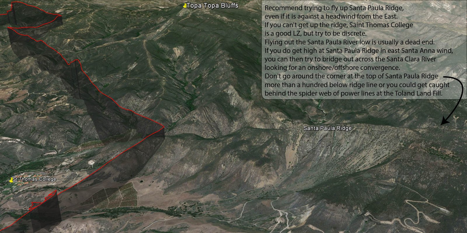
It appears that Dave does like to hug the ridge line and high ground, but I suspect he is also flying a fast glider. Regarding his choice to fly out the Santa Paula River... I wasn't there, so I'm not sure it's appropriate to Monday Morning quarterback the guy who tore it up in 2013 with numerous record flights, including a new California PG Open Distance mark, but generally, I'd recommend trying to fly (or claw) up the Santa Paula Ridge, even if it is against a headwind from the East. If you can't get up the ridge, Saint Thomas College is a good LZ, but try to be discrete. Flying out the Santa Paula River low is usually a dead end. If you do get high at Santa Paula Ridge in east Santa Anna wind, you can then try to bridge out across the Santa Clara River looking for an onshore/offshore convergence (but you want some assurance it's not blowing 40 down river). Don't go around the corner at the top of Santa Paula Ridge more than a hundred below ridge line or you could get caught behind the spider web of power lines at the Toland Land Fill.
Click JPG Image Below ↓ for Full Size HD
(1920x960)
and or Click on the East End Placemarks at the bottom of Dave's Google Earth [KMZ
File] to zoom to various views
See Also / other Casitas Pass Comments from:
[General Casitas Pass Comments 2/2004]
and
[Tim Barkers's
1/2/2014 EJ to Nordhoff Flight]
and
[Chris Lorimer's
2/4/2020 EJ to Nordhoff Flight]
and
[http://scpa.info/sites/front_range/casitas_pass]
[Top of Page] [Home]