and the Google Earth [KML File] and Sundowner's [Saturday Photos]
click on the JPG image below ↓ for full HD size
[Home] to paraglide.net [SD Log] [Amigo] [Activity] [Photo] [Comments] [Incidents] [Weather] [SBSA] [SCPA]
Saturday, 1/25/2014 [Weather] [NAM] and [Flight Articles] by [Jonathan] & [Sundowner] [SD Photos]
Saturday, 1/25/2013
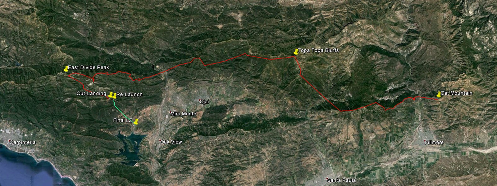
Flight 1 ~ Oat T-Hill hop to knob 250 below launch / Launch & Land about 12
O'clock
Flight 2, Launch 12:45 / Land 3:15
Leg 1 - Oat Mountain (Fillmore) westbound to East Divide ~ 30 miles
Leg 2 - East Divide eastbound to out landing in White Ledge Meadow ~ 3.8
miles
Flight 3, Re-Launch from Superior Fuelbreak and land at the entrance to Lake
Casitas
Re-Launch just after 4 O'clock / Land about 4:15 ~ 2.7 miles
about
~ 2 hours 45 minutes total airtime
Trango
Sundowner's Flight Report, see also Sundowners [Weather
Perception] and his
[NAM skew-t Forecast Discussion]
and the [Flight Path
JPG Image] and the Google Earth [KML
File] and Sundowner's [Saturday
Photos]
Took a look at the NAM skew-t forecast Thursday afternoon and got locked in on Saturday. The forecast wobbled a bit, but by Friday night I'd bought into a non-refundable kitchen pass. Rousted a few pilots out of their comfort zone for a meet time, but Saturday dawned under a solid overcast so most of the crew got cold feet at the prospect of a long drive to oat mountain (40 minutes from Carpinteria) to watch the condors. Mark Pratt was skeptical but willing to host and Jonathan was already on the road from Long Beach when I checked in, so at least we still had 3 pilots (but Mark didn't fly). Calm up to Santa Paula which was waffing offshore at 2 or 3 knots, but not enough to lift the flags. More wind as I approached Fillmore on the 126. The tall palm trees at Vons were showing what you want at Bates, but the forecast was for decreasing east wind with on-shore flow in the afternoon. We could see a blue edge approaching rapidly from the south and the satellite loop on Jonathan's phone looked like full sun was eminent. I'd pushed the 9:30 meet time back to 9:45, and we were heading up the hill by10 o'clock.
A tad windy from the east at the lower launch, so we opted to visit Ron's homestead to kill an hour, but burned 20 minutes while Jonathan toured the roads for a parking spot before heading down the big drop in Mark's 4 wheel drive. The boys have owned the ranch for 10 years, but it was my first time down the back side. Ron gave us the upper half tour. Impressive! Reminded me of the Rainbow Skyport days, but a higher order of magnitude and polish. We skipped the lower 40 tour because the day was getting on and it seemed to be calming down in the canyon. Up top it still seemed a windy, but we went to the upper launch for a look.
On launch the wind seemed manageable. Cycles were coming mostly straight in from the SE, zero to maybe 13ish, but it seemed more like wind than thermals. I started setting up and Mark spotted a pack of ravens (or large crows?) marking a thermal out front. They gained a few hundred, but didn't sky out. Got off around Noon and went fishing out front. Found a couple buoyant spots, but was only able to S turn and didn't center up. The wind out front was more east without much of a south component. Opted to set down with a side hill landing going east on the south side of the lower knob about 250 vertical below launch. Mark boosted me back, but we and to walk a hundred yards because Mark was leery about driving out the grassy road to the top of the knob due to the fire hazard.
Jonathan was suiting up when we got back, so I laid out a little further west. He pretty much followed my path with similar results. The options if you aren't getting up are to continue down toward the lower launch, but if you still don't get up you need to either top land or bail OTB (it wouldn't be OTB later in the day once the west side heated and started drawing in). Top landing in the hang glider is doable, but considerably less appealing compared to flying a paraglider. Jonathan fished a bit further than my first attempt and finally went west lower than preferable. He did gain a couple hundred back on a bounce a little ways into the lee, but it wasn't something I would have stopped for in my PG. Mark inquired if I'd rather go through the lee side rotor turbulence in a HG or PG, and my response was hands down it is less anxiety on a HG.
I wasn't going to make it 0 for 3, so I took off and angled right when I hit the buoyant air, drifting west over the ridge, gaining a little, and then turning west when I fell out the side to run across the river through the expected sink and rotor wiggle. Didn't get spanked or even take a tip fold, but I was on guard and flew conservative trying to keep it straight and level. Did encounter 1 or 2 large amplitude gyrations, but it drops off steep, so I had plenty of terrain clearance. Didn't let go to get the speed bar un-stowed until I got out of the lee side stuff over the river.
Came in pretty low on the other side (1400ish MSL?). Nothing at first, but I continued to press in well below the ridge and stumbled on a bubble below the same place I was stuck for an hour in October. Zigged up to ridge line pretty quick and though it was going to be easy with the SE flow, but then it went calm and I realize it was pulsing and I'd have to work the cycles. Did better in the next pulse but fished too far and almost flushed again before tracking a low fart out front back to the ridge. Now that I had it mapped, I was able to avoid the edges and tracked up for a thousand foot gain. Pretty easy going once established, working downwind up the long ridge toward San Cayetano with comfortable altitude, occasionally tracking thermals a little ways OTB. Got into the mid 4s and was able to clear the front point of San Cayetano without having to fly around the lower spine. Fished up to the back and turned hard to hold on in something that was being fed from multiple directions until it smoothed out a little higher and went to 65. Got to 75 on the west end of Santa Paula Ridge where it angles down toward the college and went OTB with the flow from the ESE for the Topa Bluffs.
On previous Ojai trips against east wind flying eastbound from the Repeater, I try to press upwind around the SE corner of the Bluffs to get on a good trajectory line to track the cores up and over, so it was a treat to be coming in downwind from the other direction. Came in at the top of Puckers with 55, a little below the rim looking at the vertical rock wall up close. I reminded myself that due to the ACA I dropped my discontinued health insurance in November and my new policy didn't kick in until February. Had to hold on for a ride the first few turns, but it got organized a little above the rim. There was a band of high clouds shading from Twin Peaks to just in front of the Bluffs, so I wanted to get high enough to reach the sun on glide. Fished up to the NW corner of the Bluffs, gaining all the way, and topped out at 85 hundred. Didn't bother to get the camera out because it wasn't crystal clear, I already have plenty of pictures form the Bluffs, and the clock was ticking if I wanted to get over Casitas Pass.
Got an ok downwind glide, but not as good as 10 days ago. Saturday's lapse rate was better but the tail wind a bit less, so I stopped for a little bounce over the back bump on Chiefs spine for a few turns. Back to 55 on the spine behind the Stooges. Seemed like I was out of the east and starting to encounter a little drift from the SSW. Came in on the middle bump leading down from the Nordhoff Watch Tower and found some weak lift. Fished up to the tower, but could only get into the mid to upper 5s drifting from the SW. Followed the back ridge and angle out a little on the spine running down to the Pyramid, but cut over to Spine One about half way down. Hit a couple of buoyant stretches, but my last circle was at Nordhoff. Crossed Hwy 33 with 42 over Friends Ranch.
Got a good glide going across. On bar against light flow into the gap as I approached Bump One. Had enough altitude to go for the back of Bump One rather than having to claw up along the lower ridge. Did a few of turns in a robust thermal, but the drift was drawing pretty stiff into the gap against my route, so I pulled out at 32 and went to Bump 2. Got back to 32 and easily reached across to the SE spine below Bump 3. Flew up the spine and around to the SW face and held on. Bump 3 is very reliable, but it feeds from multiple directions so the cores can be punchy, even late in the day. Only got to 42 plus, and I like to have 45, but the clock was ticking. I sensed the back ridge would work and it did. Went around the Back Step a couple hundred below and zigged up above ridge line, but only got several hundred over. Followed the back ridge up to the High Step and started to dive for the saddle behind White Ledge, but it was buoyant all the way, so I fished out over White Ledge Peak looking for 6K to cross toward East Divide.
Counseled myself several times on the way up White Ledge Ridge not to reach upwind for East Divide late in the day without sufficient altitude. Been there, done that. It's a long uphill jump to the highest point on the coastal range, and late in the afternoon, the east side is shaded, cool, and sinky. Wanted 6 plus, but committed to the back ridge route with 53 because it had been working all day and I only needed one more good thermal. If I could get around East Divide, I'd likely get up at West Divide because it is more defined and works good late in the day. From there I should be able to make civilization on glide (Cate School or better) because the west wind was light. Hadn't heard anyone on the radio in hours, so I broadcast a blind transmission that I was westbound from White Ledge for East Divide along the Back Ridge. My next transmission was that I was flushing eastbound off East Divide for an out landing in Casitas Pass and I didn't know if I'd make it around the low South West Bump below White Ledge to get out of Coyote Creek.
I thought I had a chance westbound about half way to East Divide, getting back above ridge line on the sunny faces, but as the back ridge rose abruptly approaching the Peak, there were no sunny faces and I sensed the bottom starting to fall out in the lee side shade, so I tried to get around the next lower SE flute, which I did, but low. Fished a little ways SW toward the spine, but the best I could do in the sun was break even with the wing level, and there was more shade up ahead. There is another lower SE flute, but I already had experience attempting that reach in April 2012, so I took my medicine and ran back eastbound across the canyon for the sun.
It was questionably if I was going to make it around the SW spine of White Ledge to reach the trail. The thought of dealing with the aftermath if I went down in the creek bottom short of the trail (Forest Route 4N05) wasn't even fathomable. It was my son Sam's birthday, and rather than getting home early by landing in the school yard next door, I was looking at spending the night hiking. I committed to cut straight across for the highest sunny intercept I could reach rather than flying out the canyon. My spirits were lifted on the other side as the sunny faces were still breathing. I was low and it was late so the thermals were weak, but every glide extender cut a half hour off the hike. I tried to circle or figure 8 several times, but the best I could do was break even. I was torn between gambling all in or using the bubbles as skips to reduce the hike. I did eke out a couple of 50 foot gains with a turn or two, but would then end up leaving lower than arrival. My emotion fluxed from excitement at the prospect of climbing out and getting back in the game to the cold realization that I'd likely be hiking a long ways on my bad ankle with a heavy pack after dark.
When I rounded the SW Spine of White Ledge, I had the trail made. I was below the low SW Bump, but it was my best chance to climb out. I was too low and too late. Gave up on a little fart after a few 360s, 50 lower than arrival. I got a buoyant downwind glide up the trail toward the meadow skipping off the low knobs. I've landed on the trail short of the meadow numerous times, both in HGs and PGs, so no need for a GPS. Mostly used the bubbles as extenders because if I could reach high on the trail it would bypass most of the uphill hiking. Just before the saddle between White Ledge and its foothill meadow, I scored a hundred foot gain that got me over the saddle. I thought once again that I might climb out of the woods. I only need a couple hundred more to clear the front foothills and reach Lake Casitas, but I fell out the back of the lift. White Ledge Meadow was now within reach so I didn't dare gamble my gain searching upwind. I continued on a little ways downwind past the saddle.
There is a private dirt road (De La Garrigue Road) that goes down the back of the front foothills toward the Taft Valley. I considered continuing east on the rocky ridge trying to reach Taft's valley, thinking that I might be able to beg a ride to Hwy 150. The route was in the sun, but it looked long, iffy, and possibly lee side down lower behind the front foothills with sketchy landing options. I opted to cut across the gully southbound for the meadow and reached up as high as I could on the trail below the First Bump. I could have cleared the meadow, but not the additional foothills further out front, and if you get trapped in the bowl it is all tall brush with no trails. Most pilots generally hike to the Middle Bump for re-launch (one bump east of the First Bump). I set down on the trail on the west side of the First Bump about 75 vertical feet below the top.
My intention was to hike to the Middle Bump without packing up. It was only 6 or 7 hundreds yards to the re-launch knob, but it was about 3:15 and it can be difficult to get airborne late, so I didn't have time to pack up. I did need to strip off my outer clothing layers so I didn't go into overheat on the two uphill stretches. I was getting unbuckled when a 4 wheel ATV came over the First Bump from the east and my heart soared. Drew Johnson was a friend of the Taft Family (the Taft family lives down the dirt road), visiting from Salt Lake. I explained the time constraints and Drew helped stuff the glider and tie down the gear on the front of his ATV using the 1/8" Dacron cords I carry. We were on launch at 3:30 and it was still coming in from the south with an occasional turkey vulture passing in front.
The Superior Fuelbreak (fire break) was pretty clear 15 or 20 years ago when they had cows grazing, but it is getting progressively overgrown. Laid out for a reverse pull-up into the south wind, but there wasn't enough umph to attempt it, so I re-oriented to try and run crosswind down the fire break using a front pull-up (seems like I follow the same progression every episode, but maybe I'll adjust and skip the south layout next time). After 3 failed pull-up attempts, I said I'd give it one more try before packing up. Drew was willing to give me a ride down to the Highway, but flying down was preferable and much faster. My first pull attempt was on flat ground, but I progressed further west with each try so I'd be running downhill on my 4th attempt. With all the scruffy brush, I couldn't get the canopy to come up at all on the flat. Heading downhill, I was having trouble getting it to come up straight because one side kept getting caught. I was getting out of the harness on each attempt to configure the layout. On the 4th attempt, I got the whole wing overhead, but it didn't come up straight and helicoptered. Since I was close, I needed to give it another try. Did a pickup this time and walked back to the optimal spot, then directed Drew to spread and configure the layout without getting out of the harness. Drew kept a little span-wise tension the right side and it came up clean. Ran crosswind down the fire break and gave it some left as I got light on my feet. Elated to be airborne. I don't think I could have gotten airborne with Drew's assistance. I would have run out of time.
Setting up for the re-launch attempts, I had stuffed all my gear in the luggage compartment except a jacket and helmet. Didn't wear my flight suit, gloves, vario etc to save time getting airborne. It was buoyant on the glide out with drift from the west, but without a vario it was hard to tell if I was going up or down at times. Got a better glide than usual and stretched it to the Lake Casitas entrance, landing across the street. Picked up and walked over to the green grass to pack. Made some phone calls and used the bath house to clean up.
Mark Pratt had driven Jonathan up for a 2nd flight, but we took 2 vehicles for 3 pilots on the first trip because we needed Mark's 4 wheel drive to visit Ron, and we needed Jonathan's racks for his hang glider. Mark picked up Jonathan with Jonathan's vehicle on is first flight, but Mark took his own vehicle down after Jonathan launched on his 2nd flight. Mark drove through Ojai to fetch me in his vehicle while Jonathan packed up at Vons. I was intending to give Jonathan a ride back up to his vehicle on launch, but he scored a ride with the son of one of the property owners. He got a little lost in the dark on the way down, but finally made it out as I was approaching the east end of Ventura on my way home.
I was happy to get home at 6:30 instead of the next morning. Special thanks to Mark Pratt for being a super host as always, and to his wife Chris for letting him spend the day with us rather than doing chores and tending to his grandson.
We stretched Dr Pratt's previous flight to Nordhoff High School by a few miles, but I think we are dialing in on what it takes to reach the beach, so I don't expect the new mark to stand another 11 years like Mark's previous record.
I apologize for my Google Earth KML files with no altitude info in the crude hand drawn flight paths. The flight paths are only representative when looking straight down. Now that I've been tracing my flights in Google Earth, I'm motivated to get a GPS so it will be easier to log, and the quality would be much better enabling me to refresh my memory. I don't always recollect my moves accurately due to the many successive maneuvers overwriting my RAM. I put some Placemarks in the Google Earth KML files. If you double click on the Placemarks (preferably the Placemark names in the Sidebar rather than the pushpins), you can fly to different views.
see also Sundowners [Weather
Perception] and his
[NAM skew-t Forecast Discussion]
and the Google Earth [KML
File] and Sundowner's [Saturday
Photos]
click on the JPG image below ↓ for full HD
size
[Top of Page] [Home]