[Home] to paraglide.net [SD Log] [Amigo] [Activity] [Photo] [Comments] [Incidents] [Weather] [SBSA] [SCPA]
Sunday, 9/28/2014 [Weather] and [Flight Articles] by [Ron Faoro] [timobarker] [BobA] [Sundowner] [Photos] [3D Google KMZ]
Sunday, 9/28/2014
Leg 1 ~ 5 1/2 miles Westbound from the Skyport past the VOR Spine, but
short of Painted Cave
Leg 2 ~ 57 1/2 miles Eastbound past Piru
total distance around 1 turn point ~ 63 miles
3 hours 36 minutes airtime, Launch at 11:25 and Land at 3:01 PDT
Trango
Sundowner's Flight Report, see also [Weather Archive] [Photos] and [Google Earth 3D KML File] or [raw IGC File]
Santa Barbara Season Opener!
Another lengthy article. Only my 2nd flight generating a 3D GPS track log, so I'm still spending excessive time reviewing and Monday morning quarterbacking. If you have dual monitors, I recommend viewing the Photos and the 3D Google Earth Track on your big screens while reading the narrative a your smaller screen.
Wasn't intending to fly. The Nam forecast soundings looked unimpressive, but checking the winds aloft forecast about 7:30 Sunday morning indicated a good lapse rate below 4 to 5K. We had our first post frontal blow of the season the day before, but Sunday's forecast was for much less velocity, decreasing wind from the NW at altitude throughout the day. My perception was a nice tailwind in the manageable range, with a good lower level lapse rate, some potential for low cloudbase, but burning off and lifting enough for potentially adequate altitude to get over Casitas Pass, so I punted my to-do list and sounded an alarm to rally the troops. My rationale on putting off real life must complete task was that it was the first day of the season and the flag needed raising.
There were early clouds on the range behind Carpinteria with bases in the mid to upper 3s. I was slow getting out the door and met Ron Faoro at East Beach about 10 am. We picked up Dave Bader at Parma. Everyone seemed to be a little late pulling the trigger, including the Eagle Bus which was scheduled for 11 o-clock. We sensed that it was already soarable and didn't want to squander more minutes waiting for the bus. My Toyota is a bit small, but I wanted to test it after installing a new radiator and removing the thermostat, so we stowed overload gear on the bike rack and headed up. It did ok most of the way, but on the last climb from Flores Flats the temperature gage spiked and it boiled over just as we arrived at the Skyport.
The Rock was cycling in solid from the SE and would have been high enough. The Bypass was cross from the east. The Skyport was noticeably cool with adequate early cycles, but there were some long lulls. There were scattered clouds both out front and above launch with base around 4K. Terry Taggart and Kathleen showed up while Ron and I laid-out side by side. Ron was off first and got up but he looked a bit timid and rusty. I was hooking in when Kathleen started hollering repeatedly "he's coming down!"... I looked up to see the last 20 seconds, before he disappeared out of sight over the edge. I shed my gear and was about to head down the SE spine when Ron came on the radio and assured us he was ok and unscathed. I thought of hiking down to help him with the extraction, but the sky was calling so I put my flight suit back on. The Eagle Bus arrived as I was suiting up.
Climbed out easy and transitioned over to the R&R, but could only get into the upper 3s. Searched around and finally out front. You could get almost as high out front, so I went to Cathedral and beyond, past the VOR Spine. The drift was already out of the SW above 3K, and there was a little northwest nipping at the tops of the thermals on the west end of the range. The early thermals were organized but had some sharp edges in the cool air. I took a number of tip folds and got spanked by a full stall approaching the VOR Spine. Half way to Painted Cave I started encountering building NW wind coming through San Marcos Pass. Been there done that, so I opted for the easy route and turned around at 12 noon to head eastbound. Passed under a number of westbound pilots.
There were a bunch of Hang Gliders setting up at the Eliminator as I passed in front of the Skyport. Terry Taggart was in the lead reporting the Ramero Road Cut when I was arriving over The Factory at 12:20. Pretty easy going with a light tail wind and adequate altitude for connections, but I did need to come in tight in a few places. A bit leery when getting close to the terrain due to the sharp thermal edges and the memory of my earlier full stall plus Ron Faoro's decent into the rocks. Terry opted to fly out to Padaro Beach from Ramero, so I was on my own. Cloudbase behind Carpinteria had risen some earlier, but lowered again in the stronger midday lift, down below 4K. Terry was concerned about getting through Casitas Pass with the peaks in the clouds, but due to the weather forecast and time of day, I was expecting cloudbase to lift enough. One of the reasons I did an upwind westbound leg off launch was because I was concerned about the lowering cloudbase over the high terrain through Casitas Pass. Doing the westbound leg adjusted my timing to arrive at Noon Peak on schedule.
After navigating the Devils Heart route a couple weeks earlier, I was inclined to be over-confident about crossing Casitas Pass, but I forced myself to do an objective evaluation. Terry made a conservative call, but if he had left from Castle Ridge rather than Ramero, he likely would have been able to reach the east end of Carpinteria. The altitude was adequate along Castle Ridge, but it looked marginal going uphill into Casitas Pass. I kept going, mindful that with a little west wind, it can be a long glide out if you go too far east. It's better to leave from the middle of Castle Ridge because the glide out would have a downwind component compared to a longer glide from the Power Lines which would also require crabbing into west wind. Cloudbase through Casitas Pass looked like it was lifting by the time I reached the end of Castle Ridge at 12:55. The strong sink in places was a concern, but the west tailwind was just about right, enough to shorten the glides, but not enough to negatively distort the thermals.
Angled out the SE spine from the Power Line Crossing because cloudbase was too low to hug the back ridge past the Power Lines. The SE spine worked and I easily connected over to the Noon Peak Trapezoid. Only got into the low 4s on the first pulse and considered reaching across the canyon for the lower spine in front of the saddle below West Divide, but I counseled myself to be patient early in the day, thinking cloudbase would continue lifting. I'd encountered some strong sink in places and might find more trying a low canyon crossing. You need to shift gears at Noon and transition from ridge running and skipping across small gaps to getting high for a bigger uphill canyon crossing. In addition to being an uphill jump, reaching back for West Divide from the Noon Peak Trapezoid is also committing deeper behind the foothills, so coming up short can result in a long hike or even an off trail overnighter. Since I was topped out below go altitude, I opted to search up the spine behind the Trapezoid, thinking that I might be able to work the back ridge across toward West Divide, but I couldn't get any higher in the back. Came back out front to the Trapezoid for another try and caught a good core that went to almost 5K for an easy downwind connection across the canyon to West Divide Peak behind the lower saddle.
West Divide had some shade but good clouds on top. Had to scout around a bit and work some weak stuff before a fat smooth thermal finally pulsed through. Climbed to 57 hundred for an easy quartering downwind connection to the SW spine of White Ledge. Despite my apprehension along Castle Ridge, and the typical delay at Noon, it was an easy crossing and I didn't encounter any other issues until I ran into overdevelopment behind Upper Ojai. The scenery through Casitas Pass was spectacular, but my photos from cloudbase are a bit hazy.
Cloudbase in Ojai was adequate, but the top of the Bluffs were a thousand above base, so the high back route was not a consideration. Would have preferred to get higher than I did at Twin Peaks because I don't like relying on the West Repeater Front Point, which can be fickle, but my Twin Peaks thermal petered out in the low 4s. I didn't want to push back upwind to try a another pulse, and going up the spine toward Chiefs Peak would have been a time eating detour off course with the high route closed above cloudbase, so I headed across the canyon. Further ahead, East Repeater and Boyd's were in the shade, but West Repeater was in full sun. I didn't hit anything on a trolling pass over the top so I tested the saddle behind the point, but I didn't have enough altitude to search up the spine. Didn't find anything and didn't want to get trapped, so I started to fly back upwind toward the back side of the point, but tracking a little offset from my downwind troll. I found a tight core, still on the back side of the point. Needed to keep extending my upwind leg for the first half a dozen turns, but it finally opened up and I went to Cloudbase.
Overflew East Repeater without hitting anything and kept going for Boyd's, which was in heavy shade under building overdevelopment. The key word being building. Found a weak smooth Energizer Bunny thermal that kept going and climbed a little over cloudbase. Got re-oriented about 5 minutes later passing Saint Thomas College and flew up Santa Paula Ridge. Had to go around the front side due to the clouds. Tried to hug the face near ridgeline along the western end, but got progressively lower and didn't find anything going to cloudbase over the lower tip of the SE spine of Santa Paula Peak, a thousand below the Peak.
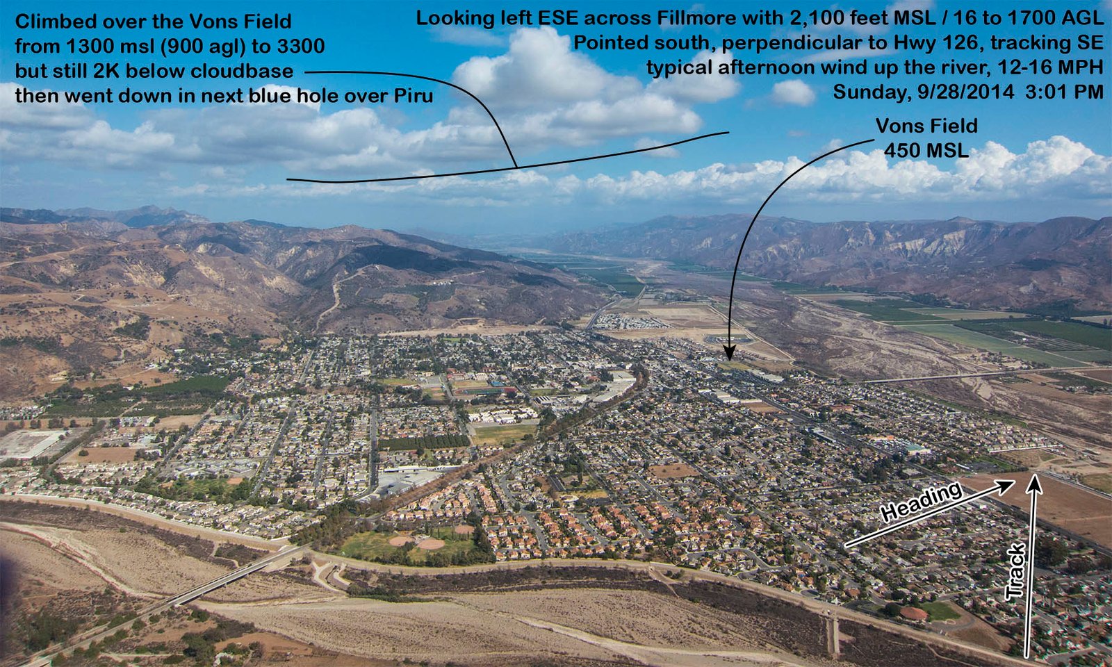
Considered going around the corner toward San Cayetano Ridge with the objective of crossing the Sespe and connecting at Oat Mountain, but the bus stop was on my mind so I opted try a glide toward the Vons field, leaving with 4K. The drift from the west was significant. Kept cranking in more upwind crab angle until I was pointed perpendicular to Hwy 126, then got on the speed bar for a short stretch until I knew I'd be able to reach the Highway. I wanted to be on a downwind line to the Vons field. Once I got on that line, I found some light bubbles and drifted with them, initially gaining 700 feet, climbing from 1300 MSL to 2K over the Vons. It was decision time. Throw out the anchor and catch an early bus all the way back to my car at East Beach, or go with the flow. I'd been debating the potential dilemma for the past hour and had told myself that if I could reach the bus stop I'd be happy with an easy ride back to East Beach, but the clouds looked tempting, better than usual over Fillmore (see photo), so opted to commit with no chase and promptly fell out the back of the lift.
Pulled a good downwind glide through buoyant air to the hills east of town, only loosing a couple hundred feet. Encountered a weak thermal over the satellite antennas in front of the Fillmore "F" and climbed back up from 18 hundred to 33 hundred. Early in the climb I thought I was going to cloudbase and the Interstate, but mid way through I became concerned that my weak climb rate wasn't getting better with altitude and I was approaching the back end of the clouds. My trajectory was too shallow and I was going to drift out the back end of the lift. I tried to extend upwind a number of times, but would fall out the front of the thermal. I was over a terrain juncture when I topped out (still 2K below cloudbase), where the low ridge I was on turns about 20 degrees to the right. I sensed that I should commit back in away from the river, but took the turn toward Piru, away from the cloud street that was angling to the NE away from the valley running east.
From there is was mostly a fizzle. Did get another skip over the flats just west of Piru that got me to the low ridge east of town, but the wind was mostly parallel to the ridge and I only found scraps directly over the crest. Unwilling to commit in low behind power lines on the south side of the convoluted ridge, I threw in the towel to look out front. I had enough to maybe make one last desperation run downwind, but the fields to my immediate east were developed so I opted to stick with a good LZ and put it down.
Packed up and called Dial-a-Ride. The operator said their last shuttle from Piru was at 5:15. They will normally detour some to pick you up, but they won't go past the Arco AM/PM. The 5:15 bus out of Piru wouldn't actually do me much good because it would only get me to Fillmore, and the last weekend bus out of Fillmore is 5 PM. The last weekend bus from Ventura to Santa Barbara leaves Pacific Coast Mall at 5:20, passing Santa Clara Street about 5:30, so you need to catch the 4 PM bus from Fillmore to make it all the way back to East Beach. There is a 9 PM train out of Ventura, but that is a long layover. The late day bus connections will become less of a time crunch once we go back to standard time, but in September, you can miss the last bus if you land late away from the bus stop.
I used to hitch hike with my hang glider along Hwy 126 in the 80s. The average wait time for a ride was about 45 minutes and my max wait for a ride was occasionally as long as 2 hours. I only spent the night under my wing once, but it was also a 2 lane road back then (one lane each direction) with a 45 mph speed limit. I think now a days the average wait time is probably about 2 hours and you might spend all day without getting a ride from freeway speed traffic, so I walked a mile and a quarter back to the Arco AM/PM. From there I had the option of trying the stop light or the traffic exiting the station. I opted to try the station, but was running out of time. There were 2 sheriffs cars when I arrived talking to a group of people. One departed toward Piru, but the other departed my direction so I flagged him down at 20 minutes till 5. Officer Tom said it was against policy to give rides, but in my case he would make and exception. He even let me ride in the front seat. He dropped me at the bus stop in Fillmore with 10 minutes to spare.
I still needed transportation from Ventura to Carpinteria, and I didn't want to wait till 9 PM for the train, so I called Pam and offered to take her and Tess out to dinner. I have to acknowledge others who were also willing to offer support. Ron Faoro would have driven out from SB if I asked him. He helped coordinate because I don't have a smart phone (yet) or any numbers stored in my phone. He got me Mark Pratt's number who gave Ron several numbers including Alan King. Ron called Alan and Alan called me while I was en-route to Fillmore with Officer Tom. Alan would have driven out to Piru with the intention of getting me to the bus stop. Alan lives in Santa Paula so I would have missed the last bus out of Fillmore, but might have made the connection in Santa Paula. Thanks to all who helped, even if it was just listening or pointing me in a potential direction. I was time limited, so I apologize for not being more social on the phone.
Reflection: A couple of weeks before, I had Diablo on lead chase. Once I was in the desert, my range of options was vast. I was confident Tony could collect me from most anywhere I went. This past Sunday I was keeping Hwy 126 within reach, which works occasionally, but more often than not you will flush along 126 before reaching the Interstate. If I had chase, they might not have been able to collect me if I detoured NE at Fillmore, but at least someone would know where I was. Having a ride home is a luxury (arguably a necessity in the open desert), but when I've been out of radio contact for hours, I'm more inclined to cling to some semblance of civilization. I've fizzled skipping downwind along Hwy 126 more times than I can count. I've had more success when I'm willing to detour away from the road to the north, but on those occasions, I've had chase.
It was a colorful day. Perhaps I should be bored with the same route I've done a many times, but no 2 days are the same and I enjoy both the scenery and the immediate challenge of connecting the dots.
[Top of Page] [Home]