I'll add some more detail, photos, and polish to the article in a few weeks, but I wanted to post something for a rainy Tuesday (5/7) reading. Unfortunately, I've used up my current time budget and need to move on to other obligations.
mph
kph
[Home] to paraglide.net [SD Log] [Amigo] [Activity] [Photo] [Comments] [Incidents] [Weather] [SBSA] [SCPA]
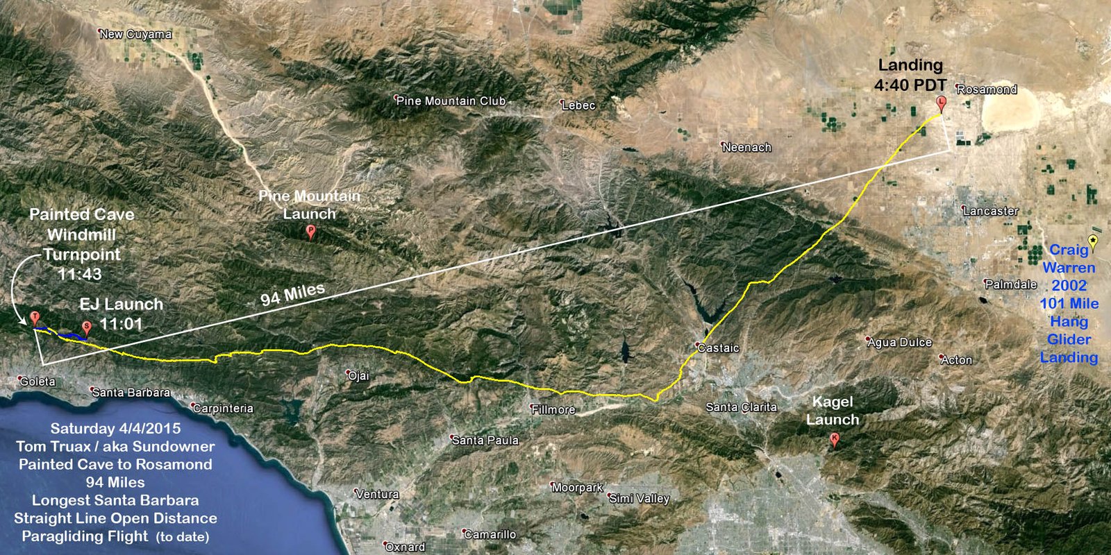
Saturday, 4/4/2015 [Weather]
and [Flight Articles]
by [Southside] [Gracecab] & [Sundowner]
SD's Google Earth [KMZ
File] plus [IGC Data File] and
[Photos]
| Leg | Miles | Duration | Time | Average mph |
Average kph |
Description |
| 1 | 1.7 | 7 minutes | 11:01 to 11:09 | 14.6 | 23.5 | EJ's Launch to the Alternator |
| 2 | 1.2 | 8 minutes | 11:09 to 11:17 | 9.0 | 14.5 | Alternator back to La Cumbre Peak (waiting for the day to light up) |
| 3 | 3.7 | 18 minutes | 11:17 to 11:35 | 13.1 | 21.0 | La Cumbre Peak to the VOR |
| 4 | 0.4 | 3 minutes | 11:35 to 11:38 | 12.0 | 19.3 | VOR double pump (say hi to Chad and Lee Anne) |
| 5 | 1.7 | 5 minutes | 11:38 to 11:43 | 10.4 | 32.8 | VOR to Painted Cave Windmill |
| 1-5 | 5.5 | 42 minutes | 11:01 to 11:43 | 7.9 | 12.6 | EJ Launch westbound to the Painted Cave Windmill |
| 6 | 63.1 | 3 hours 27 minutes | 11:43 to 3:11 | 18.2 | 29.3 | Painted Cave Turn Point to Dogleg Turn Point (County Line) |
| 7 | 40.7 | 1 hour 29 minutes | 3:11 to 4:40 | 27.4 | 44.2 | Dog Leg Turn Point to Landing Field (short of Rosamond) |
| 112.5 | 5 hours 39 minutes | 11:01 to 4:40 | 19.9 | 32 | Total for all legs 1-7 |
Longest Leg / Pained Cave to Rosamond / Straight Line Distance: 94 miles
Distance around 1 Turn Point 103.8 miles (Dogleg Distance)
Distance around 2 Turn Points 109.3 miles (Dogleg Distance plus westbound leg
from EJ Launch to the Painted Cave Windmill)
Distance from EJ's Launch to Touchdown 89 miles.
Landing was in a dried out alpha field
1-1/4 miles west of Hwy 14 (35th Street West) and just north of Avenue A (325
yards) or 3-1/4 miles north of Hwy 138
Avenue A marks the southern edge of the town of Rosamond, so technically landing
was in Rosamond, but about 3 miles short of downtown
Niviuk Icepeak 6
Sundowner's Flight Report, see also [Weather Archive]
I hadn't had much heart for flying since Ron Faro left us. I knew the desire would come back, but I was trying to refocus on paying the rent. Turned my radio on while working at my desk on Friday and watched a number of pilots flying over and around Casitas Pass, which energized me somewhat. The day looked fun, but the distance potential was limited due to Santa Anna flow on the east end of the course. A couple pilots quizzed me about my take on the weather for the weekend and I promised I'd take a look Friday night, but I didn't get to it until 6:30 am Saturday morning. I was just going to take a quick peek for a public posting without intending to fly, but when I saw the Skew-T forecast soundings I was shocked by the potential and drawn in.
I charged my radios while listening to the action the day before, but still had to scramble to re-align my priorities. Southside (John Scott) was at Home Depot intending to fly Sunday, but I twisted his arm and he brought up the rear with TQ (Todd Quayle) and Max Hogan with Diablo (Tony Deleo) for Crew. Dave Bader and Bob Hurlbett were off to visit relatives for the Easter weekend, and Neal Michaelis had to work? Posted an alert on the Discussion Page and Chat Box, then a 9:30 meet time at East Beach after SA (Rob Sporrer) convinced Jon Blake to make an early run with the Eagle Bus from Parma at 9:45. Mobile from my house in Carpinteria with Tom Livingstone in Chris Ballmer's car at 9:15, then loaded into Peter Richner's SUV at East Beach for the run to Parma. Closed the doors to head up at 9:50 with a dozen pilots on board, so we had seats to spare.
It was oozing up at the Rock, but weak. Seemed to be early. Same a the Bypass. John Greynald was coaching / crewing for a HG pilot at the Eliminator when we arrived about 10 past 10. The cycles were weak but getting better. We were going to wait to watch the HG wind dummy but got impatient and headed up to EJs where the launch conditions were sweet. Coming almost straight in from the SE about 5 to 8 mph.
Aaron set up right away and did the honors, stepping off about a quarter till 11. He made it look fat with a few wingovers right after launch, boating around in smooth air, but it seemed more like ridge lift than thermals so his altitude was limited. I was 3rd or 4th off with an initial pull-up attempt at 11 am. Took a couple of tries to attain my canopy's cooperation, but was finally able to dance around some bushes and hop over the last one.
Got about 400 over La Cumbre Peak, but the day seemed early. The west wind was forecasted to push through, but the flow was still from the SE. Spooned over to the Alternator and fished out into the saddle a ways, but didn't find much. I figured I could do a west bound leg with the SE flow, but was hesitant to give up the high ground so I spooned back to the Peak. Some pilots had gone to the RnR, but it still looked like it was working better up high early. It was continuing to build. I opted to go west again and found a nice thermal on my 2nd try fishing into the saddle in front of the Alternator Launch. Climbed from 4K to 46 and went west toward No-Name.
Did a turn over No-Name but opted to keep going. Chad gave a condition report from the VOR launch indicating light flow from the SE, so I got on the speed bar and dove for launch to say hi to him and Lee Anne. Worked a thermal back hoping to bump into a NW convergence, but had to come back out front and try again. Got higher on the 2nd pulse and went west for the Windmill with 4900. Got there pretty quick, but when I turned back eastbound with 4100 the SE flow was a bit more. Seemed to be a venturi funnel through San Marcos Pass. Got on the speed bar and bobbed back to the VOR spine. Found a good thermal over the spine and climbed from 3100 to 4900 in 14 turns. The day seemed to be turning on pretty good. Dolphined over No-Name to the peak above Westbowl and got to 5300 for an 1800 foot gain in 10 turns. The drift was still slightly from the SE, but the thermals were going almost straight up.
I went into race mode with altitude to spare and plenty of markers ahead on course. Got stuck at Noon for a few minutes, but went fishing in the back, which usually doesn't work for me but did on Saturday and I climbed to almost 54 hundred drifting from the SSW for an easy connection to West Divide where I picked up 11 hundred feet in 6 or 7 turns to 5700. Hammer tagged White Ledge and reported he was headed westbound with 65. I ribbed him a bit about heading home early on a day we were going to Palmdale with chase, but Hammer helped out with the retrieve logistics getting a vehicle with racks to pilots who landed near Bates.
I took the back route behind White Ledge and hit a boomer just past the saddle, climbing from 5100 to 6700 in 7 turns. No need to stop with way more altitude than necessary, went on a 7 mile dolphin glide across Hwy 33 to Spine One where I stopped to pickup up 1300 in 5 turns, climbing from 3900 to 5200. The midday winds aloft forecast was actually calling for more of a tailwind down lower and lighter flow from the SW up higher, so there wasn't much incentive to get real high. Did 4 turns along Nordhoff in cores that were too strong to pass up and went off the east end with 6700. Dolphined across Twin Peaks and stopped behind the East Repeater front point for my highest climb of the day, going from 4700 to 8700 in 11 turns. That's almost 400 feet per turn, or a sustained climb rate of 775 feet per minute. That was enough altitude to glide all the way (7 miles) to the top of Santa Paula Ridge, arriving a few hundred over and fishing up the ridge line to the peak just west of Santa Paula Peak where I found another boomer to climb from 5200 to 8200 in 17 turns. Fished back behind Santa Paula peak a bit and left with 83 plus at 2:27 PM with plenty of time remaining.
So much for the easy stuff. Beginning of part 2. Considered angling in toward Hopper Mountain behind Oat and then Baldy behind Piru to stay deep and away from the River, but there was a pretty good south component in the flow down low, so I'd need to get pretty high at Hopper and Baldy to justify the deep line. The low front line is more conservative, but usually doesn't work due to cooler river air, but the lower level south component to the flow should yield better action along the low hills and ridges, so I opted to keep the river and road within reach.
I'd left Santa Paula Peak pretty high. Nothing over San Cayetano Peak as expected. Up high there was a little drift from the north which was good because I was expecting significant drift from the south down lower so I went with the drift. I came in with pretty good altitude across the river, about 4500, and encountered buoyant air over the hills one canyon north the river ridge. The air was buoyant but smooth without anything to climb on. I wanted to stay a little deeper, but I also didn't want to get trapped in the canyon behind the river ridge. Started crabbing to the right as I encountered increasing flow from the SW down lower, with a lot of south in it. Finally ended up pointed perpendicular to the river with half speed bar to clear the front ridge. The track log shows a line running ESE, but my actual compass heading was actually almost straight south.
Got over the front ridge east of Fillmore with 3200 and hit a thermal drifting from the SW. Tracked it back to 45 before loosing it. Though I was in pretty good shape but encounter sink alarm on my next glide so I had to angle out again on speed bar to power through the sink even though I was going downwind. Burned through 1800 feet on a 3 mile glide before encountering a bounce just before downtown Piru that got me back up to 3K from 2600. From there I skipped along the low ridge east of Piru, losing another thousand feet, but encounter some bubbles at 2K, (about 1200 agl) and drifted with the 7 turn thermal coming off the fields WSW of unnamed 2300 foot peak at the county line.
I guess we need to name the mountain so I'll call it County Line Peak or County Line Mountain (we keep referring to it as the unnamed peak). It's a shallow triple peak mountain just under 2300 on the Val Verde Topo Map just north of Hwy 126. The Ventura / LA county line runs between the slightly lower eastern peak and the 2 higher western peaks. The higher more pronounced peak is on the Ventura side of the county line. The main spine runs mostly east-west, parallel to the river, but there is low point on the south side of the mountain that juts out toward the river that occasionally offers up a thermal, so we'll call it County Line Point. The county line angles from NNW to SSE so the point that juts out to kink the river flow is almost a mile on the Ventura side of the line. Seems like points that jut out into the river sometimes offer up thermals on their back / downwind side. Not sure what causes the phenomena. Perhaps it's the wind wrapping around the point, or the diffusion downstream of the venturi, or thermal bubbles being able to form in the protection behind the point?
Anyway, got back to 2300 hoping to track up to the peak, but the thermal trajectory stayed out front. After losing it I opted to try the point rather than committing back into the mountain. The mountain is pretty shallow with power lines running across the front, so if you don't get up it might be hard to come back out against the wind and you can get trapped behind the lines. Sometimes you need to flip the coin and try one or the other, avoiding the temptation to split the difference. Playing for the point was less anxiety in the wind, plus John Scott had climbed out from 2900 to 7900 over the point few weeks earlier during his [73 mile flight on 3/15], however, in retrospect, John's thermal came off the SW side of the point and tracked up over the peak so it must have been fed from the fields on the SW side. I flew right over where Southside caught his 3/15 thermal but only found down air. I kept going for the point itself. and found what I needed just past the point on the lee side where the terrain wraps back in. Had to keep extending the upwind leg to avoid falling out the back, but the thermal trajectory indicated it likely came off the protected lee side fields because it tracked somewhat across the river flow up the mountain toward the north before the wind got the better of it and the remnants angled downwind to the NE.
Climbed from 2100 (1200 agl) to 4300 doing 11 turns in the initial pulse drifting from the SSW, and then searched directly downwind to the NE for a mile and half, turning on scraps, loosing a couple hundred before encountering another 15 turn core that boosted me from 4100 to 7200 while drifting a couple miles to the NNE.
I felt pretty good with a new SB PG straight line distance record within a downwind glide. I was out of race mode and in obstacle course mode, working anything that was break even and taking the drift. After topping at 7200 about 4 miles NW of the Castaic Junction, I lost 1100 feet on a short mile and a half 135 second glide downwind through sink, heading NE toward the Castaic Lake Dam, averaging 40 mph with a little speed bar through the sink. Got back to 69 drifting for a mile in light lift and then lost a hundred over the next half mile drifting in weak lift before falling out and burning 600 feet on a short glide to the Castaic Lagoon where 3 turns were good for 400 feet and another mile of drift across the lagoon.
Weighing my options. I would have preferred to be a bit further south to run up the San Francisquito Canyon toward the Del Sur Ridge on the south side of the canyon that has worked for me in the past, but I was too far north and didn't want to spend my altitude fighting cross wind. Red Mountain is NE of Castaic Lake and it seemed to be mostly straight downwind. I was a little concerned that the lake might dampen any potential thermal activity, but there seemed to be plenty of dry land around for thermal production, so I committed toward Red Mountain and lost 1700 feet gliding downwind along the edge of the lake just north of the Lake Hughes Road. I picked up 300 feet half way through the glide at the NE corner of the lake, but it was mostly down air. I started getting concerned about the landing options as I continued to lose altitude, and my down wind ground track over 3 miles from my last bump was averaging 44 mph. High groundspeed is good over flat terrain, but they call it canyon country for a reason. I could see where I landed in the wind back in 2002.
Diablo had been in radio contact for awhile. He knows the layout better than anyone, including me, so it was reassuring to hear his encouragement and advice. Red Mountain Peak at 4K is the high point along a ridge running ENE. The south side is fed by a series of spines that are higher on the north end and taper toward San Francisquito Canyon to the east. I veered left and made a play for the prominent spine to the north, but was keeping an eye on San Francisquito Canyon because if I didn't get up I'd want channeled air for landing. None of the landing options looked good, but some were better than others and you want channeled air if you have to put it down in the wind. Arriving at the spine with 3900, a little below the peak, I picked up a couple hundred to 41, but the trajectory wasn't going to be good enough to clear the rotor if I had to go OTB. I needed a thermal out front so I'd have some room to give on climb before getting blown over the back, so bailed from the prominent spine a half mile upwind of the main ridge to cut eastbound across the spines with some ground to give toward the ridge on drift. Was mostly breaking even around 4K in the ridge lift falling off toward the San Francisquito Canyon. 3/4 of a mile and a couple spines east I did a couple of turns and got to 4300 but still didn't like the trajectory, giving up a little ground to within 600 yards of the ridge line. Got on the bar and put some more crab angle into it for a little more separation. A mile further east I hit what I needed, a 5 turn thermal that went from 4K to 4900 with a good trajectory.
I could now reach the next mountain to the NE, Tule Ridge, and with a little more help Green Valley was within reach. Green Valley is smallish, but the largest open space around with a quarter mile long field that looked like the best option for landing in the wind. Cleared the Red Mountain rotor and got a good downwind glide doing a few turns to gain another hundred feet to 5K. Green Valley was about 4 miles downwind and sits about 3K MSL, so I had a little room to fish, but a few skips would help. Hit a thermal at 4500 over the spine running down from Tule Peak toward the SE across the wind. It was weak at first, but after drifting with it for a mile and gaining 200 feet in 5 turns, it opened up and angled upstairs another 3000 feet to 7600 in 16 turns over a 2 mile drift. From here I had the Antelope Valley flat land within glide so I was elated to survive and attain a long time goal.
Hit another thermal just past Grass Mountain and topped out over Lake Elizabeth at just under 8K. I'd made the Antelope Valley, but due to the dogleg I hadn't put on many more miles, so I considered running ESE along the Liebre Mountains toward Palmdale, but it would have been cross wind with a lot of crab angle and I'd likely get blown out into the Valley anyway. Diablo recommended running straight downwind and I concurred. One more decent thermal over the flats would get me to the hundred mile mark, so I was willing to turn on anything. At a quarter past 4 pm, the day had some life left in it, but all I found were scraps for a few hundred feet a few times. It was mostly final glide, but I was clocking a healthy ground speed.
The WJF archive for 5 PM recorded 21 mph wind gusting to 30 and my GPS was showing a ground speed around 50ish. My track log for a 3-1/2 mile downwind glide over 4 minutes shows a 52.5 mph average ground speed.
It was going to be windy on landing, but it was late in the day and the air was pretty mellow despite the desert wind. Kept hoping for anything to latch onto, but it just wasn't happening. Down to a hundred feet across scruffy ground cover, I opted to turn and throw out the anchor over a dried out alpha field rather than eking out another quarter mile or 2 and dealing with the brush. I'd stowed my radio and unclipped one leg strap earlier. I had debated about unbuckling or getting dragged, but it seemed like the turb wasn't too bad so I opted to unbuckle the remaining leg strap and chest strap after turning into the wind. I was backing up a little but could penetrate on speed bar so I rode a little bar to the deck and stepped out of the harness, holding onto one brake handle. The harness rode up the brake line as expected, turning the canopy sideways. It gave a pull as expected, but then went pop, breaking all the break lines on the right side and sailing away. In the future I'll need to modify my technique with the high performance dental floss lines to run at the canopy and avoid the shock loading. It broke 5 lines where they went through the pulley. I think the break point was mostly from the inertia load of the harness so the canopy itself wasn't stressed.
Took a photo of the canopy and walked over to some trees to get got out of my flight suit next to a couple covers to the field pumps. Went back to collect the glider. No way to pack up nice and neat in the wind so I got out the stuff sack and started at the downwind tip.
I had called Diablo after un-suiting. I though he would be my ride home, but he was collecting John Scott and was likely an hour and a half away. While stuffing the glider the phone rang. It was Eric who had landed past Fillmore. Peter had picked him up. Peter had talked about chasing, but I hadn't heard him on the radio all day. Eric said they were on Hwy 138 looking for me so I relayed my position before the call was dropped. Rather than burning time trying to reconnect, I continued stuffing and got to the road about 2 minutes before they pulled up.
Glowing ride home. Dropped Eric in Ventura. Stopped at my house just after sunset to glance at the track log, then took Peter to dinner at The Palms. Dan Yager, Tom Livingstone, and Lua Pepper came by to share a table and their flight stories. Tom finally logged his first flight to Ojai after 20 years. Home, shower, archive the weather observations, and then a good nights sleep.
SB Records
To the best of my knowledge, Saturday's flight is the longest PG flight from Santa Barbara, and maybe the 2nd longest foot launched flight. Back in March of 2002, Craig Warren logged the one and only hundred mile flight from Santa Barbara on his Wills Wind Talon Hang Glider, landing east of Palmdale. I flew the same day but flushed in the NW venturi spilling over San Marcos Pass. I was able to get back to launch and fly 68 miles to the a windy landing in the San Francisquito Canyon, which I think was the previous SB PG distance mark prior to this past Saturday's flight to Rosamond.
Craig Warren's [101 mile HG Flight] on 3/2/2002 / Current HG and foot launched record
Tom Truax's [68 mile PG Flight] on 3/2/2002 / old PG record, but there are numerous longer HG flights
I think the SB Tandem record is a 63 mile leg I did with [Randal in November 2003]
Reflections
I've wanted to cross the Liebre Mountains from Santa Barbara for decades. Of course, in my fantasies, I always go a hundred miles or more, but the reality is what it is. It was more of a technical race day rather than a scenic flight day. If I'd just looked a the sky without consulting the weather models I wouldn't have suspected it was a particularly good day, hazy and smoggy down low, and the 6K temperature was only average. Friday looked much better from an air air clarity perspective, and Friday's altitudes were slightly better, but Friday was course limited due to the offshore flow. Knowing there was the potential to go to big altitude (for the front range) played into the strategy.
My emotions fluxed during the flight. Kind of a slow start but when it turned on it was easy so I was fairly confident after leaving the VOR that I'd have a play at the far end of the course past Fillmore. The run to Fillmore was low anxiety for me, partially because I know the course, pitfalls, and the fast lines pretty well. After Fillmore my emotions fluxed with each thermal, scrapping along the low river ridges trying to reach the County Line where the lift occasionally gets better. It was initially low anxiety after getting up at the County Line, but my mind was racing due to all the possibility. I'd successfully crossed Liebre Mountains from the Front Range to the Antelope Valley only once in a hang glider many years ago after launching from Pine and flying out to Ojai. I'd gone up the San Francisquito Canyon low and finally connected to big altitude at cloudbase over the ridge that angles off to the right of the Bouquet Reservoir (ENE) and flew east of Palmdale.
On Saturday I went with the flow and had better altitude compared to past attempts. John Greynald did a similar crossing 15 or 20 years ago while he was still in his 40s. I was logically scarred due to the wind hazard and the potential to loose control in potentially nasty mechanical turbulence down low, but the mental demands didn't permit me to dwell too much on the fear factor. Crossing a series of canyons and ridges in the wind isn't like running down the range. You can't simply keep going. You have to plan ahead somewhat and strategize to avoid the pitfalls. Unfortunately, it's usually windy trying to cross up to the high desert on robust days because the Santa Clara River feeds the desert through that corridor.
There are a bunch of course options that vary with the weather. I've been successful on the range south of the river in my hang glider, but I think it's more common to angle NE along a similar line I took on Saturday. Angling NE has worked at least 3 times now, once for me on my paraglider, once on my hang glider, and at least once for John Greynald. Creg Warren flew more up Hwy 14 before GPS track logs were common, but my experience is that Hwy 14 tends to be sink a hole.
It is personally rewarding for me to see a mild resurgence in the cross country flying. We used to try and go XC every weekend in the late 80 and 90s, but after the big records fell with mega flights it seems most XC pilots either got old or lost interest in the adventure. It's exciting to have high caliber pilots exploring our local mountains in the soaring season and I love the energy of our younger pilots. It will be a different sport for them compared to my career. They have better knowledge, data, and equipment, so they should be able to extend well past the modest marks we've made.
Once again, the extra performance of the IP6 is impressive, extending my reach and giving me the speed to get out of trouble. It would be hard to return to a lower performance wing.
Additional Notes
Craig's 101 mile foot launched record remains intact for now, but with a number of accomplished young PG pilots flying Santa Barbara in the Winter months, it seems only a matter of time before Craig's foot launch record falls to a Paraglider. Not many HGs getting on course these days, so his record might continue to endure as the HG mark. Craig now lives in Colorado and mostly flies his high performance sail plane.
John Greynald actually had 2 hang glider flights to the Antelope Valley. His first flight was in the 75 mile range landing somewhere near the base of the Liebre Range in the Vicinity of Elizabeth Lake? He also had a 2nd flight in the 90 mile range landing near Palmdale? Reportedly, on his 2nd flight John flew to the VOR first. Not sure of his landing location or how his distance was measured, but the 90ish mile number might be from the Eliminator, so perhaps his longest leg distance is actually in the 95 mile range. On his first 75ish mile flight he must have taken a similar route to my flight on Saturday. Not clear about what he took for route on his 2nd 90ish (or 95ish) mile flight, but he landed near where I did on my hang glider flight along the front rang from Pine, so perhaps he took a similar route up the San Francisquito Canyon or more likely a route closer to Hwy 14 similar to Craig Warren's route because the landing options for a hang glider are better.
[Top of Page] [Home]