[Home] to paraglide.net [SD Log] [Amigo] [Activity] [Photo] [Comments] [Incidents] [Weather] [SBSA] [SCPA]
Saturday, 9/14/13 [Weather Archive] and [Flight Articles] by [BobA] [NMERider] [Sundowner] [Fly Above All]
Saturday, 9/14/2013
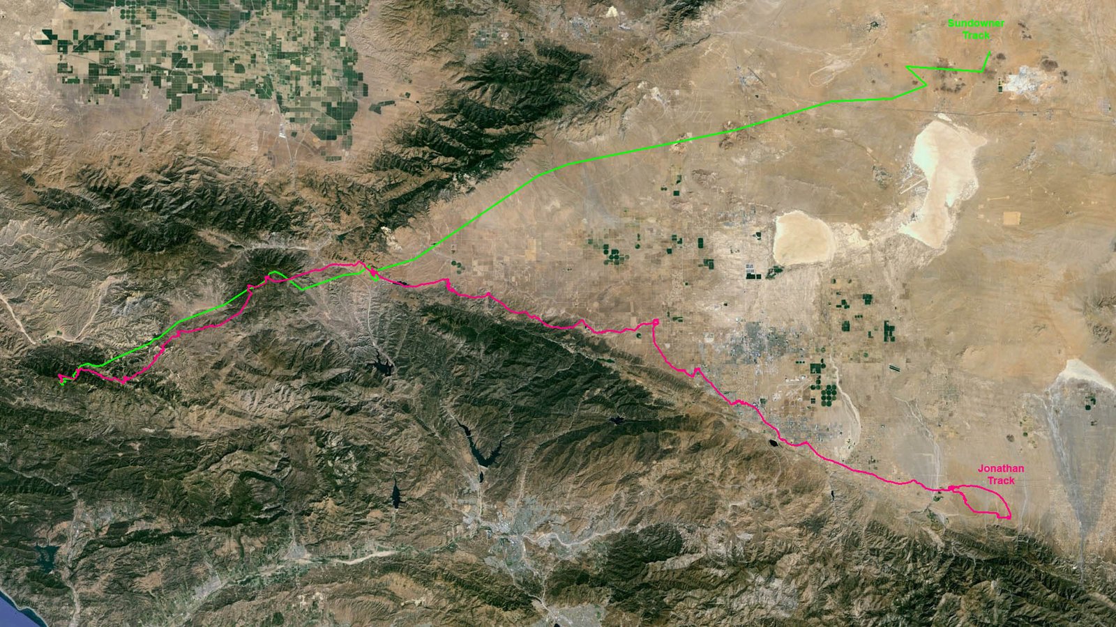
93.5 miles straight line from launch to touchdown
about 5 1/2 hours airtime / Launch at 11:20, land about 4:45
Trango / with first flight in new flight suit from Fly Above All
Sundowner's Flight Report, see also [Weather Archive] & Track [Image] or Google [KML File] (need Google Earth to view KML file)
Hadn't flown the mountains since June 1st (15 weeks) and not at all since a summertime tandem with Tess at Bates on Father's day (13 weeks). It was easy to find reasons not to fly with Pine closed until a couple of weeks ago, but it opened right on schedule for September. I got several phone calls from the usual addicts notifying me that Saturday looked good. A weather check on Friday confirmed the rumors, and I wasn't committed to scheduled activities. September can be prime time at Pine, but the days are trending short fast as our yearly sine wave approaches the fall equinox where the first derivative peaks at maximum absolute value. Diablo made the decision to commit easy, offering to crew even if no one else showed up.
Despite advertising open seats in an air conditioned vehicle with racks and seasoned crew on an obviously promising XC day, only 3 pilots loaded into Tony Deleo's Land Cruiser across from the bus stop at Ash street in Ventura. Jonathan Dietch (HG), Bob Anderson (PG) and myself (PG). It was already cycling in good when we got to launch at 10:30. I took my time because I didn't want to go OTB too early and flush. Laid out on launch and suited up in the shade. Airborne at 11:20 into a mild cycle. Made a couple of passes, but there wasn't sustaining ridge lift, so I had to run out for the knob from a hundred below the road. Tracked a thermal back up to the spine over the trees where the east/west drift converged and it opened up for a steady climb without much drift to 11ish.
Went to Rayes and found another that went to 12K drifting from the SE. I spotted Jonathan about 12K at Pine during my Rayes climb. He came in under me, but didn't find the center and continued east up the north side of The chute. I started to follow ESE up the north side of The Chute, but the drift was from the SSE. I didn't want to fight the south so I let it drift me north of the ridge hoping for convergence that I didn't encounter. Angled for Guillermo and pulled a bad glide on bar through strong sink. The other 2 pilots pushed upwind to the back of Chute and around the rim of the badlands, getting much better glides. It was dicey if I would make Guillermo. About 8500, I had to decide whether to bail for the 50/50 or reach for Guillermo. I figured I could at least make the meadow on the SW side of Guillermo. I'd landed there before with Brendan and Dan Keyser and was able to hike up, re-launch, and connect to cloudbase. An uphill hike in the peak heat of a hot day wasn't appealing, but the 50/50 isn't some place I aspire to be either so I opted to reach.
Came in a couple hundred over the meadow but below the peak. Had a little drift from the south so I went with it toward the north edge and bobbed downwind into some buoyant air that got better and drew me toward the NW spine. Hanging on to anything is better than hiking uphill in the heat. Turned in a spotty 100 up fart that expanded with each iteration or two and after a few circles I was even with the peak and climbing steady. It's always nice to get the first low save out of the way, especially when the stakes are high. Topped a little over 12K and got a buoyant glide for a couple of miles toward Frazier.
About half way to Frazier, I spotted Jonathan circling around 9K on the west side of the mountain. About that time I encountered strong sink that lasted all the way to Frazier. Reached the north side of the SW spine with 8K and worked the ratty lee drifting from the SSW. Wrestled several wiggly cores to gain 1500 before I latched onto one that sent the vario off scale. Worked out to the SE corner, still below cloudbase with 12 plus. The cloud tops were curling from the north, but the flow below cloudbase was from the south. There were haze domes pulsing over Hungry Valley to the south. It can be hard to get across I-5 against an upper level flow, so I spent a thousand feet for position dolphining upwind through glide extenders along the eastern edge of the haze before turning left with 11K to fly SE toward Booster Junction (the intersection of 138 and I-5 near Quail Lake).
Crossed I-5 a little south of Gorman with 8K, tracking along Gorman Post Road, still angling for Booster Junction . Down below 7, I opted to veer left and get on the grassy ridge just east of Gorman Post Road. Had a little draw from one of the flutes to my left approaching the ridge, but I didn't want to commit downwind away from my objective so I angled right and bobbed down the ridge toward Booster Junction. Down to 500 AGL at the end of the ridge and finally encountered something to circle in. Focused tight and got back to 75, drifting from the SSE. Angled out toward the pumping station east of the ridge (north of Quail Lake) and got another boost back to 85 half way there. Continued on and found a core that went up to good altitude just before the pumping station..
Diablo reported light wind on the deck switching back and forth from south to west. There was a huge dust devil coming off the fields just west of Neenach. My drift at altitude was from the south. I had to decide weather to push upwind toward the Liebre Mountains or play for the Tehachapi side. I split the difference and started to head for the big dusty west of Neenach, but didn't want to fight the drift from the south so I changed course and opted to angle for the Tehachapi Mountains. Before I got to the range, I encountered drift from the North over the base of the foothills as I got lower. It's generally bad to fight against the drift down lower because the drift is often a draw toward thermal convergence, so I opted to head straight east and found the seam with no north or south drift and got back to 12K. I could still bridge across to the Liebre Mountain Range. Jonathan was doing ok along that route, but it would be upwind to get there and the clouds looked better along the Tehachapi Range.
Went on glide conscious of the drift, sometimes angling in slightly toward the Tehachapi Range, and sometimes away, but mostly parallel over the flat terrain just south of the Tehachapi Foothills. Had a couple of episodes where I went through strong sink, but each time I got low (about 500 to thousand agl) I'd encounter bubbles drawing toward lift ahead. After a couple of gyrations, I was under the southern edge of a street running along the Tehachapi Range and didn't get low again for what seemed like hours.
Despite the good altitude, the going was slow because there was no tail wind assist. Was down to 8 over the hill/mine SSW of Mojave (Soledad Mountain) and climbed back to 14.5. The clouds street followed the Mountains north toward Red Rock, but I perceived light drift from the north at altitude (time to incorporate a gps?). There was an occasional cloud popping over the open terrain to the east. A good one formed directly over Edwards for awhile but dissipated. I don't like going upwind, so I didn't want to plug upwind toward Garlock, and I didn't want to land inside the airbase fence, so I angle ENE toward Hwy 58 to stay out of the restricted airspace. Seemed to be a light headwind, possibly light draw toward the development I left behind. Down lower, the light drift from the north shifted to light drift from the south, which was welcome because it made it easier to avoid the airbase..
Worked a few thermals for a couple thousand feet here and there, but seemed to be getting progressively lower. Diablo and Bob were parked at the town of North Edwards and reported a south wind about 8 to 10 came up blowing toward the low hills north of town. Since I didn't have that much of a south component at my altitude, I figured it might be a draw feeding a thermal that might be triggering from the low shallow hills, so I angled NE. A little west of the hill I was down to about 6K and found smooth lift that took me back up to 85, but it was drifting from the ESE. The thermal started getting light and I was giving back distance tracking the wrong direction, so I left it and plugged up wind fishing. Encountered some scraps that were worth a turn or 2, but never found another bubble big enough for a sustained climb. Tried the hills just west of the Borax mine, but only scraps. Chase had gone north about 6 miles from North Edwards along a paved road to the town of Aerial Acres, so I angled north for one last search over a low shallow rise a couple miles east of Aerial Acres because there was a dirt road (Rosewood Blvd) heading east of town toward the hill. No joy, and down to about 200 feet, so I opted to do a wind check and set up for landing into light drift from the SSW along a spur road that angled NE from Rosewood Blvd toward a picnic area just east of Alper Street.
They actually have street names on the map, and a picnic area in the middle of what appears to be nowhere, but I guess if you work a the Borax Mine or Edwards Airbase you have to picnic somewhere?
Light touch down in smooth easy conditions. Not much brush around, so Diablo drove right to me and was there about the time I got the canopy bunched up. Put it in the back of the truck before getting out of the harness and we were mobile within 5 minutes of touchdown. We were about 10 miles west of 395. I didn't have a GPS but Diablo did and he reported touchdown was at the 93.5 mile mark, which was confirmed by a distance check on Google Earth. 6.5 miles short of a hundred. Just needed one more thermal. I kept hoping down to about 200 agl, but came up empty at a quarter till 5.
Jonathan landed at Crystal Air Glider Port on the south side of the valley about 15 minutes earlier. 42 miles south of my LZ as the crow flies. Took us 100 minutes to drive around Edwards Air Base via the 58 to 395 to the 18. Google Maps says an hour and 45 minutes to drive 89 miles with no traffic, so Diablo made good time passing weekend rush hour slow pokers. Going back to Hwy 14 would have been 5 miles less, but possibly more traffic navigating through Palmdale. Direct back to Ventura with no stops, and home in Carpinteria before 9.
Special thanks to Diablo for stellar crew (how many crew members do we know who provide a deluxe air conditioned vehicle outfitted with racks and radios?) Also thanks to South Side (John Scott) for analytically support. Not like the old days when we went flying simply because it was the weekend. Now a days we need to confide in our analyst.
Also thanks to Chris Grantham at Fly Above All for outfitting me with a flight suit that fits. I'd been flying Pinky's old medium suit since Cottage Emergency Room cut my large suit off to tend my ankle injury 8 years ago. The medium suit was too tight to wear a jacket under. John Kloer dropped off the modern large size suit from Chris a few months ago, but I didn't get a chance to try it until Saturday. Worked great. Lots of pockets and zippers. Easy to get on and off. Some insulation, but not too heavy.
Click Image Below for Full size [1920x280]
or view Google Earth [KML File]
(need Google Earth to view KML file)
[Top of Page] [Home]