[Home] to paraglide.net [SD Log] [Amigo] [Activity] [Photo] [Comments] [Incidents] [Weather] [SBSA] [SCPA]
Sunday 9/14/2014 [Weather]
and [Flight Articles] by [SD] [Chris
Paul]
[Bendan] [John
Scott] [JD] [Dizzy]
[Sat 9/6 by Dizzy] / [Wed 9/10 by JD] /
Fri 9/12 by [Dizzy]
[JD] &
[Ken]
/ [Sat
9/13
Elsinore] / & [Misc Post]
Plus 2014 Mid September [Photo Sets] and [Track Logs]
Sunday, 914/2014
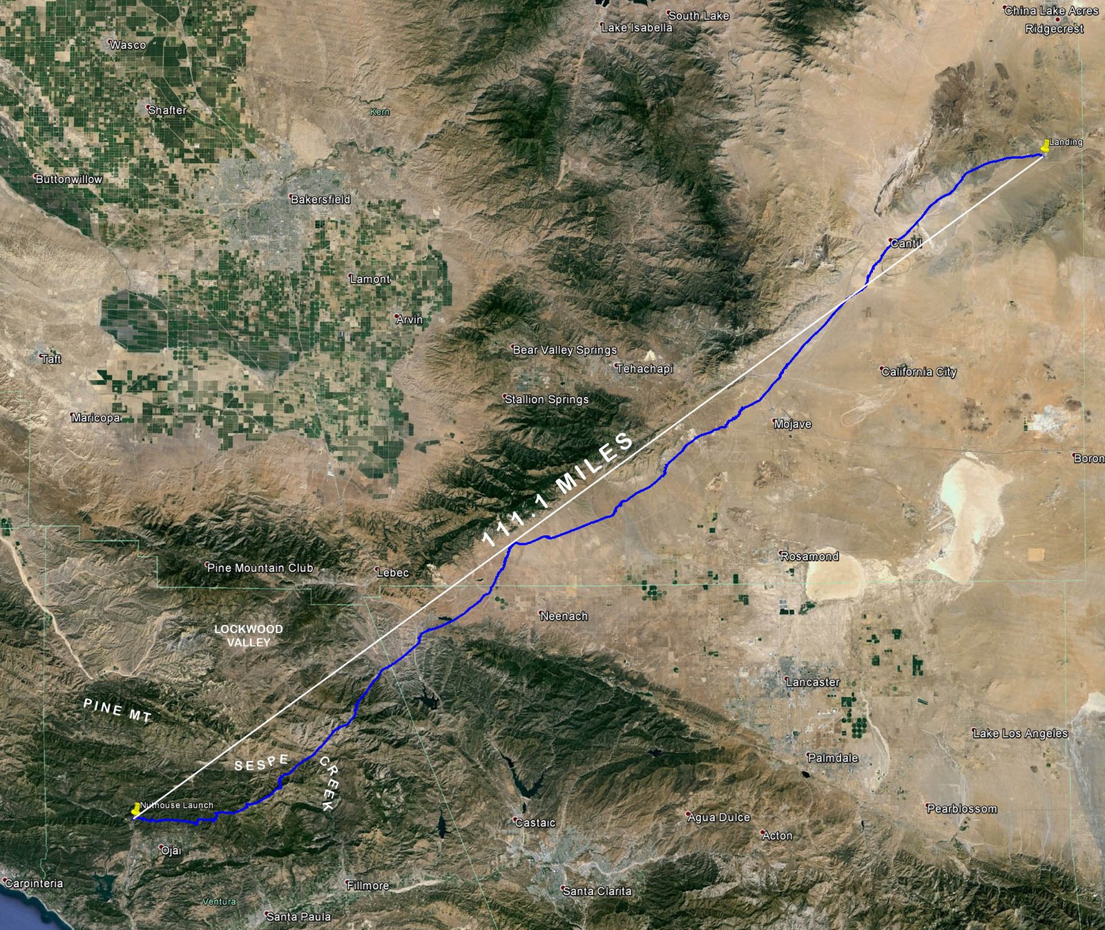
The Nuthouse Past Garlock
111.1 miles / Straight Line Distance from Launch to Landing
5 hours 49 minutes airtime, Launch at 11:22 and land at 5:11 (17:11)
Average speed from launch to landing 19 mph
Max altitude 15K over the Antelope Valley (13K higher than launch)
Launch Altitude: 1,900 Feet MSL
Landing altitude 2,700 feet (about 800 feet above launch)
Glider: 10 year old UP Trango
10/8/2014 tech note: The original measurements were taken via Google Earth
using the flight path, but I have subsequently discovered there can be a slight
parallax error that varies with the viewing angle, however, a re-measurement
using the ground track still yields a launch to landing straight line distance
of 111.1 miles
Also note that when checking my camera clock 3 weeks later, it was about 1 and a
half minutes fast, so all the photos are showing time slightly advanced rounded
to the nearest minute.
2023 Note: This was my first flight with GPS recording, so the IGC file stuff
was new to me. I re-measured with a more seasoned (2023) understanding of
measuring in Google Earth. The SLOFD from Takeoff to Landing is 111.1
miles, but max SLOFD from a Start Point to a Landing Point is 111.2 miles.
I mostly like to use the 111.1 number for multiple reasons. I might find
the time to reconstruct a more polished KMZ with my current ability to view the
raw IGC data, but the priority is low.
Sundowner's Flight Report, see also [Weather Archive]
[SD Sunday Photos] plus [SoCal
Mid Sept Photo Index] & [Misc Notes] and
[Google Earth KMZ File] [Raw
IGC File] or Track
Log Screen Shots [All]
[Zoom
1] [Zoom
2], plus [SoCal Mid Sept Track Log Index]
Warning: This was one of my more memorable career flights, so the article is lengthy. The summary numbers are posted above, but for the narrative I recommend reading at your leisure with time to detour and review some of the related articles and photos.
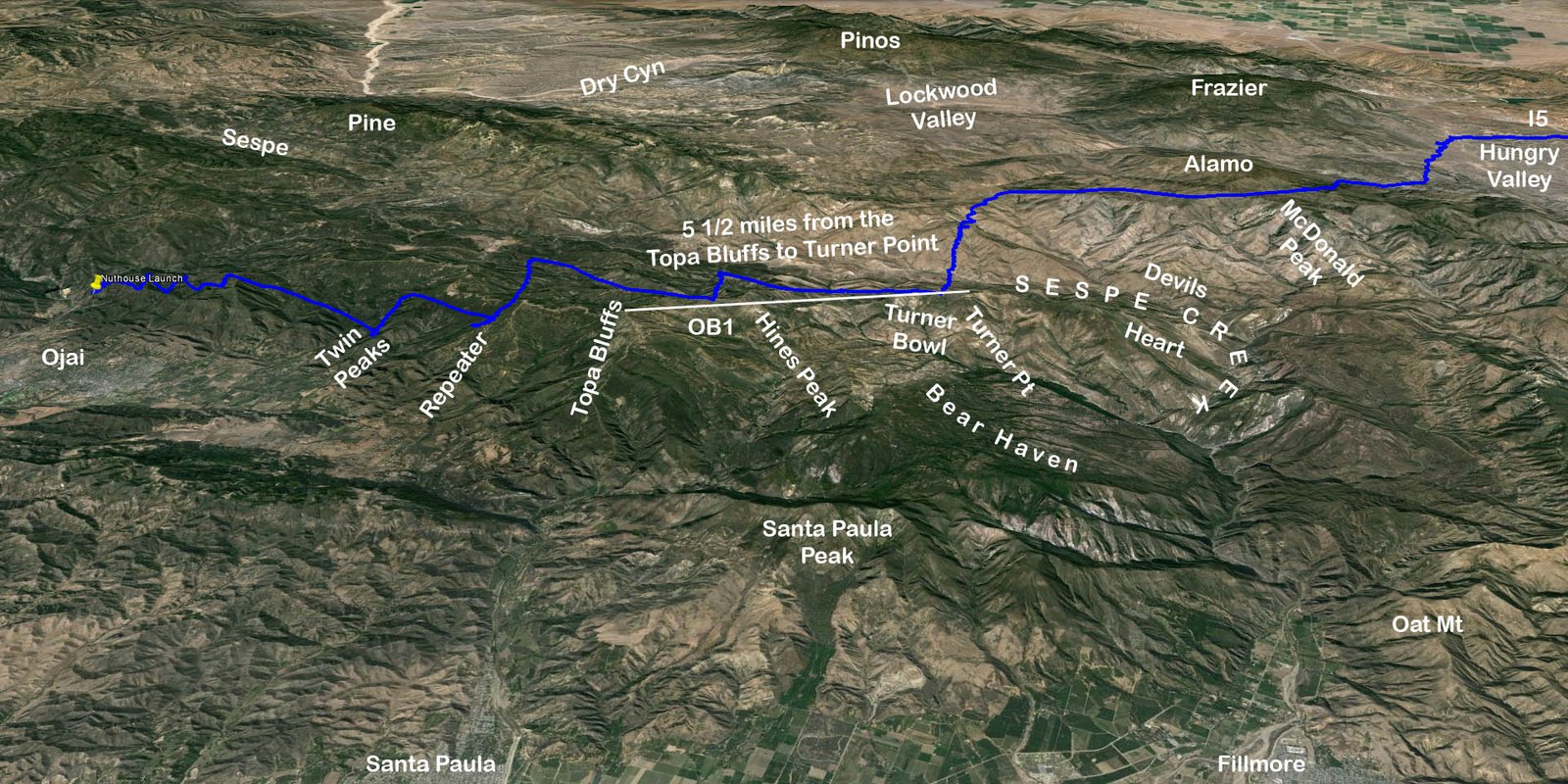
I've been looking at a short stretch of the Topa Topa mountain range running east behind the Topa Bluffs for 30 years (the Devils Heart Route). Prior to Sunday, I'd never been there, but in the age of Google Earth, it seemed like my backyard. The forecast soundings indicated we may be having one of those occasional days when you can get high enough on the front range to connect with high cloudbase over the back. On paper, Sunday was forecasted to be the peak heat day in the middle of a string of good days that yielded some impressive flights. It was hard to pass on Saturday, but I hadn't flown a mountain flight since mid May, so this would likely be my only flight this summer. (I did try to fly a month earlier but got to launch late at Pine due to car trouble)
After overanalyzing an overwhelming pile of forecast numbers, I opted to post a commitment to attempt my fantasy flight from the Nuthouse, but after hearing late reports from Edward about Max Hogan's Saturday flight from Pine, I began to vacillate and wonder if I was relying too much on the computer models and ignoring our local fudge factors. Saturday's clouds were pushed back to the north and the HG pilots couldn't get high at launch. Was it realistic to expect we could get higher on the front range in the summer? I took another look at the most recent Skew T forecast soundings Saturday night, and at the 11th hour (9 pm) made several phone calls with the intent of aborting the Nuthouse hike in favor of Pine. Fortunately my Topa Brothers (TQ, South Side, and Brendan) settled me down with a reminder that its just recreation. Ojai was sure to be a good flight even if we didn't make the epic fantasy connection. There was some early south wind, so on paper, Ojai did look like the better route to connect to the Antelope Valley and there was the possibility that Pine might be too windy at launch for PGs.
I knew the hike would be difficult so I paid attention to my diet the day before. Had to pick up Sam from his high school dance at 11:30 Saturday and was in bed before midnight. I already had my gear assembled and got up a little before 6 to log the forecast. The winds aloft don't come out until 7. Had a light breakfast and showered for some unknown reason. I guess I like to be fresh when I sweat. Out the door at 7:25 for a 7:45 meet at Ash Street in Ventura, but a mile down the road I realized I forgot my hat (could be critical equipment on a hot day in the desert) so I was 5 minutes late. We opted to take Chris's Nissan Pathfinder and leave my Toyota at the bus stop. We checked the Nordhoff High School meet spot, but no takers. Brendan was going to start hiking about an hour behind us, and the HGs were scheduled to depart Ventura at 8:30 for Pine.
The plan was to hike early because it would be over 80 degrees by 10 am and close to a hundred by noon. With extra water, food, and clothing for freezing temperatures at altitude, my pack was heavy for the hottest day of the year. We arrived at the bottom about 8:20. I did ok up the first third. The lower part had a lot of cool shade early in the day. Struggled through the middle section and took a long rest under the brush canopy tunnel a little past the midway. I was employing what I learned from Benson, who taught me to pay attention to my vitals and avoid running the temperature gage too far into the red zone. I'd blown up my Toyota radiator a month earlier trying to push just a little further to reach a good rest stop. Higher on the trail, the shade was scarce, but I'd stop for 20 or 30 seconds (sometimes longer) at each scrap of shade to let my heart pump away. At the 3/4 mark, my temperature and heart rate had climbed into the red zone and I needed to stop, but there was no shade. There was a good sit down spot just a little further up so I pressed on and made it, but after unloading my pack and collapsing in the shade an urge to vomit was welling. Thought of my son Sam pushing uphill through pain during his high school cross country meets. My vomit urge was building with each breath. I was still younger than Bob Hurlbett was on his last Nuthouse attempt, but I thought I might have to abort and head back down. Hiking down would be difficult in the building heat, and the memory of cool air at altitude was alluring. My intestinal discomfort began to flattened out after 45 seconds, and a minute or 2 later it began to reside with each breath. We were ahead of launch schedule, so I took an extra five minutes. Stopped often during the final top section of the trail, taking a little longer to slow my heart rate in the shade, and turning away from the sun to take shorter breaks when no shade was available. Extended my personal record for the longest time to launch again. About an hour and 48 minutes (10:08 arrival). At least I beat Brendan by a minute or two, but he started more than an hour after me. No bugs. Must have been too much for them on the hottest day of the year.
Hung my soaking wet shirt to dry. The sweat had even soaked through my bag so my spare shirt was a little wet also, but not much. Didn't want wet clothing in the freezing temperatures at altitude. The sound on my old Flytec 4005 had quit working several flights ago. Rob Sporrer loaned me his spare Flytec 6020. I'd spent a couple hours on Saturday reading the manual and experimenting on my bike, but the manual is somewhat random with conceptual discussion. I couldn't find instructions on how to program the custom data displays. Brendan has a 6030, but he couldn't recall the programming steps, so I'd go with just the basics. This would be my first flight with a GPS track log. My hiking shirt wasn't quite dry by the time I need to zip my luggage, but my spare was good. Opted not to wear all my clothing because I couldn't bear the thought of sweltering under multiple layers in the heat at launch.
Chris Paul was first off a a little before 11 am. It was marginally soarable. He got a hundred below launch several times and had to struggle before finally zigging up to ridge line. I was off second at 11:22ish. I little marginal on my first pass, but I quickly climbed to ridge line doing figure eights. I was 800 over launch before I settled into my harness on the dolphin glide to Spine One without stopping on the way. I didn't do a 360 until I got to Spine One and climbed to 45. Brendan was off about 10 minutes after me and he climbed out easily. Chris had left Spine One higher, but I got up good at the Pyramid and stayed in a little deeper behind Nordhoff Ridge because Chris wasn't finding much on the front side of the front ridge. I got to 55ish on the east side of Nordhoff and arrived at Twin Peaks even. Chris eventually got higher and went directly to the middle bump on the Chiefs spine. I was surprised that Twin Peaks was difficult. The early low thermals were strong, sharp, and intermittent with some long lulls in between pulses. Perhaps it was better to avoid the front points.
I finally latched onto a good core at Twin Peaks and climbed to 6K, drifting directly up the spine from the SSW. I was almost back to the middle bump when I topped out. The short term objective was to get to the Topa Bluffs, the highest terrain. At Twin Peaks I considered simply working east over the front points to Puckers (the SE spine below the Bluffs) and working up from there, but the front points had been intermittent early and from my position it was easier to reach across the canyon toward the mid section of the Repeater's West Spine. Chris Paul went to Chiefs to check max altitude there. I came in ok over the Repeater spine and fished uphill, but had to fall off and look down the spine. The lower drift was from the SSE, but I found a thermal that was drifting from the SSW that went to 95 hundred.
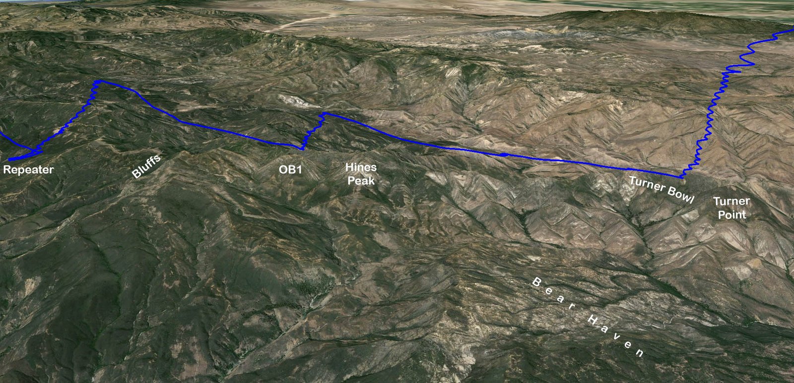
Flew to the NW corner of the Bluffs, arriving with about 8K, about 1500 over. Didn't hit anything and considered searching out front a ways. I was a little hesitant. My plan was to get high at the Bluffs before venturing back in, however, the general rule is that lift may be easier to work up high, but triggers are easier to hit down low. There was a cloud to the east that appeared to be over the end of the ridge/range at Devils Heart. I had enough altitude to reach back toward Hines Peak, but it would be committal. That was the plan, and I'd spent hours overanalyzing the potential, so I kept going and didn't look back.
Picked up 1500 at the unnamed peak before Hines Peak (gave it the name OB1 after my flight), climbing from 7K back to 86. Didn't stop at Hines Peak and kept going. Passed the watershed divide (Santa Paula Creek vs Sespe Creek) and marveled at the view. My recollection is that I was a couple hundred below ridge line coming up on the last peak that had a spine in front (about 5 plus miles behind the Topa Bluffs, or a couple miles before (west of) Topa Topa Peak, the end of the range / Devil's Heart), and starting to angle away from the back ridge to intercept the spine, but my track log says I was even with ridge line. (note: the track log also shows my max altitude about 500 feet higher than I recollect, and the track log shows my low save at 500 agl but my recollection is about 200 agl. Not sure if the track log is displaying GPS altitude or pressure altitude. Anyway, the wind was from the west (tailwind) and as I crossed the bowl to intercept the spine, I hit a thermal that took me to cloudbase plus some. Cloudbase was about 13K. The track log says I topped at 13.8K (7,500 foot climb). The lift was big, fat, smooth, and sweet. Climbing strong through 9500 it became obvious I was going to cloudbase and I was elated to know that I'd be able to reach the next connection with altitude to spare. Since I had a compass, I indulged in a little extra above cloudbase because I was pretty far from the nearest road. After the flight, I named the last point with a spine in front Turner Point, in honor of Dave Turner who has given us all inspiration, and I named the bowl just west of the point Turner Bowl.
I was going to need another thermal or two to get back to civilization, but there were clouds within reach on my course line. I studied the spines below McDonald peak the night before, thinking I might have to come in a couple thousand below, but I was well over the tops and didn't bother to deviate left to overfly McDonald Peak because it was north of the course line to the clouds ahead. I picked up 500 on the spine SE of McDonald Peak and got back to cloudbase (about 13K) between Sewart Mountain and Snowy Peak, picking up the thermal south of Stewart at 10K and climbing slow while drifting a couple of miles from the SW. From there I went on a glide toward the western tip of the Liebre Mountains, stopping halfway to I5 to climb from 10 to 11K. Climbed again over the interstate from 85 back 10K. There were scraps of clouds scattered around with heavy development over Lockwood Valley running NE along the Tehachapi Range, and a big fat cloud over the middle of the Antelope Valley before Neehach. There were also some clouds along the Liebre Mountains, but with the wind from the south I opted to overfly the Liebre Range and reach for the big cloud in the middle of the valley. Crossed Interstate 5 at 1:30
Diablo was on lead chase out front reporting surface wind from the south. I'd been having a radio interference issue with the Rob Sporrer's Flytec 6020 vario. I could get the radio to work if I held it away from the vario, but mounted on my chest strap was continual static. I was keeping in contact intermittently, but on glide toward the middle of the valley, I could hear but couldn't transmit. After getting back to cloudbase I was able to disconnect the speaker mike while on glide and that enabled me to transmit again. The static was also less without the speaker mike, so it might have been acting as an antenna.
I was coming up short on my reaching glide to the middle of the valley. Crossing just west of the round alpha fields, I turned straight down wind with the objective of staying off the ground. It was the hottest day of the year in Ojai. It was a hot day in the desert also, but not as hot as Ojai or Pasadena. On hot days in the desert, you will often encounter a heat cushion near the ground that isn't going up, but will dribble off small bubbles that are good for a turn so you can skip and turn off the gradient (like an albatross over the ocean), drift, and break even (but you have to be going downwind). I was down to what I thought was about 200 agl approaching the aqueduct (my track log says I was 500 agl) and was about to turn back into the wind for landing on the road when I hit something I could skip on. Diablo happened to be driving up the road westbound toward the pumping station, but he didn't see me. It was a frustrating to hear his radio radio broadcast saying that he lost contact with me when I was right in front of his windshield. I didn't dare let go to fumble with the radio and stayed focused on skipping along down wind from one bubble to the next in the boundary heat layer. After drifting for a couple of miles, I finally hit something that I could extend my upwind leg into without falling out the front and the climb got better with altitude. Went back up to 15K (11,500 foot climb)! Cloudbase was about 14K.
I was elated to make the connection to the Antelope Valley from the Nuthouse, but with such a good looking day the valley, I would have been disappointed to hit the deck without connecting back to cloudbase. I was in good position for a hundred miler plus. Nice cloud development with high cloudbase and a strong lapse rate on a hot day. Had a light tail wind from the SW for now plus Diablo out front with surface wind reports and advice from the experience of our most seasoned pilot. I was early, having launched early and made good time without getting stuck anywhere. It was a quarter past two when I reached cloudbase in the Antelope, 46 miles NE of the Nuthouse Launch. After the low save I went into a more conservative mode, trying to top out on all the decent climbs. I had plenty of time to make a hundred plus if I could avoid making a major mistake and dirting it. My objective was a hundred plus miler rather than max distance, which would equate to a different strategy, trying to go faster by skipping through the weak lift. My logic was that without a stronger tailwind it would be difficult to go much more than 150ish, so I wasn't going to set a new state record. Bagging the first hundred miler from the Nuthouse was a more valued objective. In hindsight, if I was just 20 minutes sooner at Garlock, I would have been in front of an advancing shade line rather than chasing the sun line.
Climbed back to cloudbase again (14K) over the new windmills. I was surprised by the windmills. I'd flown through there last year and they weren't there. Had a few ugly thoughts of trying to land in a windmill field on a windy afternoon and getting whacked by a blade and falling a hundred feet to the ground. Fortunately, I never got low around any of the windmills. Unfortunately, that was my last trip to cloudbase. Spend a lot of time around the Tehachapi Gap and Mojave trying to get back to cloudbase, but the best I could do was twelve five.
There were some scattered clouds directly east over the open desert, but the strong street was over the range (Barren Ridge). The surface wind along Hwy 14 was light from the SE and mostly SW up higher. I would have angled more left over Barren Ridge, but the sun edge was a mile east of Hwy 14. I split the difference and flew parallel to the ridge and the road half way between the two. I considered angling either left or right, but left would have been deep into what I thought was overdevelopment with no chance of getting back to the sun if it didn't work, and right would have been somewhat upwind and might have resulted in falling out the front of the lift. After my post flight analysis and consultation with Diablo, I now think that Barren Ridge was the convergence line, feeding from both sides, but feeding stronger from the west than the east. During the flight, I thought Barren Ridge looked on the verge of OD, but a review of the photos shows building clouds continuing to be feed from the west. The clouds on the east side (where I was) were old, spent, and mostly in decay.
I got back to ten eight due west of California City, climbing up from 88. Then it was a 10 mile glide. A little before the Rancho Seco Honda Test Track, my drift changed from toward the range to away from it. The east side sun line was also closer. I started hitting some teasers so I angled out toward the sun and found a weak smooth thermal and climbed from 63 back to ten five, drifting from the SW.
I wasn't sure how far I'd gone because I only partially knew how to work Rob's 6020 Flytec. John Scott was behind me when I got to cloudbase over the west end of the Antelope valley. He had moved in front but opted to throw in the towel around the 85 mile mark (from Pine). Diablo was was out front reporting the landing area for Garlock was about 98 miles from launch at Pine. Hwy 14 north of Red Rock canyon was completely overdeveloped with very little to no sun getting through. There was sun over the Garlock Range and Valley but the shade was advancing from the SW. I thought I might have just enough altitude to reach the hundred mile mark, but if I made a play for the Garlock Range and it didn't work, I might be a few miles short. I couldn't quite reach the sun line, which was moving east, so I opted to continue NE along the road toward the community of Garlock and ran into another thermal. Garlock had been light and variable, but Diablo now reported light surface wind from the SE (a quartering headwind?). It was my perception that my thermal was drifting from the east, but my track log shows it drifting from the SW. Not sure how I got that wrong. Perhaps the rapidly moving sun line rendered a peripheral illusion that I was loosing ground because the sun edge was moving further away. Anyway, I climbed from 5K to 83 and left the lift when it got weak because I though I was drifting from the SE rather than the SW.
After topping out, I considered running into the mountains again, but the rapidly moving sun line was just out of reach and the drift was away from the mountains rather than in, so I opted to look out front and tack on easy miles. Tony's mileage reports were from Pine rather than the Nuthouse. The Nuthouse is slightly east and about 10 miles south of the Pine Mountain South Side Launch. If you went straight east, flights would measure longer from Pine, but I suspected flights to the NE would measure slightly longer from the Nuthouse. Bottom line, I wasn't certain of the mileage and didn't want to come up a mile or 2 short of a hundred. Had I known that I had plenty to spare I might have played for the mountains, but I wasn't going to catch up to the sun and the drift seemed to be away from the range. Had I connected over Garlock and gotten back to cloudbase, I likely could have gone another 30 miles downwind in the late day buoyant air at altitude.
Ran east toward the sun over the road. Diablo reported a thermal stirring from the south, so I detoured left, but was already down low and only found scraps. Tony had parked at a potential LZ, but I still had a few hundred left so I kept going, hoping for a late day low save, but I got boxed in by high voltage power lines and couldn't continue downwind from the WSW. Threw out the anchor and setup for a landing on the road. Easy approach and touchdown on the pavement into light SSW wind in smooth conditions. 11 minutes past 5. Same time that Alex landed on Friday, but more than an hour earlier than Max Hogan's landing on Saturday.
Got undressed and changed into shorts. Sorted the gear and put everything in the gear bag but the glider and harness, which I stuffed in the back of the truck. Good thing I didn't go much further because when we got underway I noticed that gas gage on E. If I had gotten up, I guess Tony might have been able to reach Ridgecrest before running out of fuel. We pickup up John Scott and continued south on the 14. I don't think we would have made it to Mojave because the low fuel light had been on for 30 miles, but there was a gas station a bit east of Hwy 14 on the road to California City. Fueled and refreshed with a cold beverage, we could crank the AC and increase our speed above max glide. Tony made good time on the back roads to Neenach. Not any shorter but no traffic, so faster?. Todd had left his gear up near the base of the Tehachapi Mountains and walked 4 or 5 miles out to Hwy 138. We collected him at the Fairmont Market in Neenach. He had a good story about getting a ride along Hwy 138 to the market with the "Peach Man". He'd also made friends with the store clerk and run up a modest tab.
The boys dropped me by my car at the end of Ash Street. John's vehicle was at Todd's house. I checked the grass at Viola Fields in Carpinteria to pack up, but it was wet, so I went to one of the parking garages under a business building to fold the canopy. Home about 9:30 and had the gear sorted and stowed by 10.
Once I got to the Antelope Valley, I felt I could go anywhere and Diablo would be able to get me home. I was able to fly the weather with only minimal concern for retrieval logistics. I also need to acknowledge Edward Skow (aka Fast Eddie when he was flying Pine at the age of 15), who wasn't lead chase on Sunday, but he was on course supporting the rear which enabled lead chase to follow Team Topa Protocol which supports the lead. Diablo was waiting in the LZ with wind reports and his phone camera when I touched down.
Reflections
We left miles on the table, but for me, the flight was more than raw numbers. Down at ridgeline committed in the wilderness, days away from the nearest road by foot, marveling at the view behind Bear Haven... priceless!
As for leaving miles on the table? No regrets. Tony is calling
Sunday's adventure a
"Boutique Flight".
My longest foot launched flight ever was a 179 miler in a HG from [Pine
to Ludlow] (Hwy 40 past Barstow / 1988, 26 years ago in mid September).
It was during the days of expanding horizons and limited retrieval technology before
cell phones and GPS. Over a hundred miles past 2nd place on a day with a
lot of pilots logging personal records, I had been out of CB radio contact for
hours. Back than, I regularly hitch hiked with my hang glider, tying it
onto anything that would dare to stop. I had altitude at Ludlow but opted
to circle down to land at the last pay phone, which worked out great because I
immediately caught a ride 50 miles back to Bartow and was able to leave a voice
mail on our dedicated call in number. I have regrets to this day.
Had I kept going down Hwy 40 I would have logged over 200 miles. I might
have spent the night in the desert on the side of the road, but it's not like
being down in the Sespe at Devils Heart. It would have been worth it.
Diablo has a dozen or so 200 plus mile flights (plus nights alone in the desert
on multiple occasions). I logged the first SoCal 100 miler in a HG (September
1984) and the first 100 mile PG flight in the United States (June
1994), but as I continue through the late afternoon of my flying career, I realize
that I will never hit that 200 mile mark. Dust in the Wind.
It was good that I misperceived my drift and mistakenly left the last thermal early on Sunday. It might have meant going another 30 or 40 miles, but then I wouldn't have a boutique number like 111.1 miles, and we might have run out of gas and stranded South Side and TQ in the desert overnight. Leaving so many miles on the table will be incentive to try and collect them on a future flight.
The Perfect Storm alignment of events to bag a bucket list flight. What are the chances of randomly going 111.1 miles from anywhere let alone the single and only flight I had this summer? We needed a few things to go wrong to string the sequence together. Pine needed to be windy from the south. No permits available for Chiefs on Friday because it was hunting season, and Chris Grantham lost his designated landing area, so he didn't maintain FlyAboveAll's standing permit. Diablo's crash at Sylmar. I also needed some things to fall into place. 10 to 13K on the front range! John Scott watching the weather and sounding an early alert. Todd Quayle rallying the troops. My first flight with a GPS track log (thanks to Rob Sporrer) so I could review and share the details. The brotherhood who realigned my perspective when I became overwhelmed with options Saturday night (I wanted to fly all three sites, Pine, Kagel, and Ojai). Brothers to hike with on the hottest day of the year. Dave Turner for inspiration to trust the Devils Heart route I'd been looking at for 30 years. and...
Of course, now that we have proved the route on a day well suited for the task, I'm concerned that with my history of exercising restraint, I'll be tempted to explore the route in less than optimal conditions. I think we can connect the dots with 3 to 5 thousand feet less (8.5 to 10.5K), so I had plenty of cushion on Sunday. Back when Jim Graham became the first pilot to fly across Casitas Pass in his Comet 185 Hang Glider (large heavy glider for a little guy), "The Pass" was considered to be "Dinosaur Country". Casitas Pass still commands respect and continues to humiliate us, but we have learned to read her pulse. The Devils Heart route isn't as extreme as Dave Turner's Sierra Range crossing from east to west, but it is deeper than Casitas Pass, which has claimed life, broken bones, and resulted in numerous long hikes and helicopter rescues.
A unique nugget that the Devils Heart Route offers is an actual spur to big altitude and the back country. The coastal range angles inland (actually, the coast angles away from the range) at Casitas Pass. The range continues through Ojai with gaps at Hwy 33 and Santa Paula Creek, then peters out across the Sespe at Fillmore, dribbling on as low hills to Interstate 5, however, one might argue that Santa Paula Peak is actually a different range, a continuation of the line that starts at Rincon and continues as Sulfur Mountain south of Ojai. At the Topa Bluffs the actual Santa Ynez mountain range continues ENE to Devils Heart, back behind Bear Haven, which is a double edge sword.
The depth only leaves 3 ways out; flying, hiking (for days), or helicopter. There are no land vehicle paths in the designated wilderness area and the terrain is rugged. On the other side of the sword, the depth and altitude provide protection from the ocean air. Hines Peak is the highest point on the coastal Santa Ynez range. It is only about 500 feet lower than Pine Mountain. I think you can cross the Sespe and come in pretty low (3500 to 5K) on the spines below San Rafael or McDonald Peaks and wiggle back up to ridge line in boundary convection. On a good day with bonus altitude like last Sunday, there are multiple routes to choose from. On Sunday, I was able to skip McDonald Peak and angle more toward clouds above the Black and White Mountains. Cobblestone Peak and Whiteacre Peaks may be options on spring days from Santa Barbara when the Santa Clara River is inverted by the sea-breeze. Since the route is so inviting, someone will land out soon enough, so further investigation into the actual exit options would be a worthwhile endeavor to advance our community. I suspect that identifying hiking routes up and out of the Sespe to the north or east might offer better options than hiking down the Sespe to the south toward Fillmore or back up the Sespe to the West toward Lions Camp.
Perhaps venturing back into Devils Heart on Sunday was irresponsible. I did bring extra water, food, clothing, and a spare radio battery, but if I went down I wouldn't be physically capable of hiking all the way out on my bad ankle. Without prior knowledge of the exit options, I would need to find a spot with some degree of shade and radio reception, then wait a day or 2 for potential rescue with fingers crossed. Our sport has a lot of uncertainty. I think I've written about that concept on a number of occasions. We can't script it all out ahead of time. I prepare for my flights better than most, but my preparation pales in the face of the variables. I rely on risk vs reward assessments and try to balance my perspective. I've experienced both sides of luck and misfortune. I had a lot of confidence in Sunday's route and didn't think I was going down in the Sespe, but realized it was a possibility.
A pre-flight weather analysis of Sunday indicated that launching from Chiefs Peak offered the best opportunity to achieve maximum distance in Southern California. South wind at Pine makes it difficult for slow Paragliders to successfully navigate the multiple cross wind connections en-route to the Antelope Valley. It was downwind from the Ojai Range. On Sunday, I was at cloudbase in the Antelope Valley ahead of capable hang glider pilots that launched from Pine because they needed to take a zigzag route with some upwind legs. We also got a lot higher on the Topa Range than they did over launch at Pine because the high Pine Mountain Ridge protrudes into the upper level south wind so you often get a compression venturi resulting in a shallow thermal trajectory over the ridge.
Tony Deleo holds the unpowered aircraft open distance record from Ojai, flying across Interstate 15 to Apple Valley from Chiefs on his Atos (120ish miles). He took the conventional route going OTB from Chiefs or the Repeater to Thorn Point and connecting through Lockwood Valley (or he might have taken a more southerly route from Thorn Point and flown over Alamo Mountain). Taking the Devils Heart route is more direct. Note: Diablo still holds the paragliding open distance record from Pine with a [flight to Trona] on a DHV 2 Firebird Flame 15 years ago in 1999 (and the HG open distance record with multiple 200 plus mile flights). I think Robert Millington still holds the westbound distance record for Ojai with a flight from Chiefs to the 101 river crossing in Santa Maria on his hang glider (about 80 miles). To the best of my knowledge, my Sunday flight is the first hundred mile paraglider flight from our coastal front range. Seems like there should also be some bonus points for doing it from a hike up launch and landing higher than takeoff.
Congratulations to Chris Paul (married with kids) for his flight on Sunday, becoming the first pilot of any aircraft type to fly from the Nuthouse to Lockwood Valley, and the only PG pilot to fly solo from anywhere on the front range to Lockwood Valley. Congratulations is also extended to Brendan (married with more kids). A flight from the Nuthouse to 9500 over the Topa Bluffs (7500 higher than launch) is noteworthy.
Further Ramblings are posted under my [Weather Perception] and and [Misc Notes]. My [Sunday Photos] may also be worthwhile for someone considering the Devils Heart Route, but I didn't get my camera out until I was at cloudbase.
Click on the 3 route images below ↓
individually for full size, or view them as part of my [Sunday
Photos], or better yet view the track log in 3D with Google Earth
[SDs Google Earth KMZ File] or [all
the track logs for Sunday superimposed], or [all
the SoCal track logs for mid September] posted to local discussion boards
see also [Weather Archive]
[SD Sunday Photos] plus [SoCal
Mid Sept Photo Index] & (Misc Notes)
and [Google Earth KMZ File] or Track
Log Screen Shots [All]
[Zoom
1] [Zoom
2], plus [SoCal Mid Sept Track Log Index]
Sunday 9/14/2014 [Weather]
and [Flight Articles] by [SD] [Chris
Paul]
[Bendan] [John
Scott] [JD] [Dizzy]
[Sat 9/6 by Dizzy] / [Wed 9/10 by JD] /
Fri 9/12 by [Dizzy]
[JD] &
[Ken]
/ [Sat
9/13
Elsinore] / & [Misc Post]
Plus 2014 Mid September [Photo Sets] and [Track Logs]
[Top of Page] [Home]